You are here: Home > Network List > CI - Caltech Regional Seismic Network Stations List
> Station SMM Simmler, CA, USA > Earthquake Result Viewer
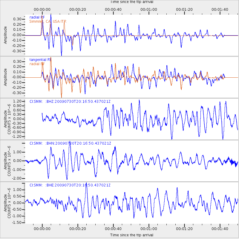
SMM Simmler, CA, USA - Earthquake Result Viewer
*The percent match for this event was below the threshold and hence no stack was calculated.
| Earthquake location: |
Tonga Islands |
| Earthquake latitude/longitude: |
-20.8/-174.3 |
| Earthquake time(UTC): |
2009/07/30 (211) 20:05:34 GMT |
| Earthquake Depth: |
10 km |
| Earthquake Magnitude: |
5.9 MB, 5.7 MS, 5.8 MW, 5.7 MW |
| Earthquake Catalog/Contributor: |
WHDF/NEIC |
|
| Network: |
CI Caltech Regional Seismic Network |
| Station: |
SMM Simmler, CA, USA |
| Lat/Lon: |
35.31 N/120.00 W |
| Elevation: |
599 m |
|
| Distance: |
75.9 deg |
| Az: |
43.183 deg |
| Baz: |
231.504 deg |
| Ray Param: |
$rayparam |
*The percent match for this event was below the threshold and hence was not used in the summary stack. |
|
| Radial Match: |
82.62426 % |
| Radial Bump: |
380 |
| Transverse Match: |
68.91545 % |
| Transverse Bump: |
400 |
| SOD ConfigId: |
2622 |
| Insert Time: |
2010-02-26 01:32:33.640 +0000 |
| GWidth: |
2.5 |
| Max Bumps: |
400 |
| Tol: |
0.001 |
|
Signal To Noise
| Channel | StoN | STA | LTA |
| CI:SMM: :BHN:20090730T20:16:50.437021Z | 6.2721224 | 7.9015524E-7 | 1.2597891E-7 |
| CI:SMM: :BHE:20090730T20:16:50.437021Z | 1.5395751 | 2.7067554E-7 | 1.7581185E-7 |
| CI:SMM: :BHZ:20090730T20:16:50.437021Z | 1.925202 | 3.8444227E-7 | 1.9968931E-7 |
| Arrivals |
| Ps | |
| PpPs | |
| PsPs/PpSs | |


