You are here: Home > Network List > TA - USArray Transportable Network (new EarthScope stations) Stations List
> Station I13A Wildhorse Creek, Mackay, ID, USA > Earthquake Result Viewer
I13A Wildhorse Creek, Mackay, ID, USA - Earthquake Result Viewer
| Earthquake location: |
Andreanof Islands, Aleutian Is. |
| Earthquake latitude/longitude: |
51.2/-179.0 |
| Earthquake time(UTC): |
2007/12/21 (355) 07:23:35 GMT |
| Earthquake Depth: |
30 km |
| Earthquake Magnitude: |
5.7 MB, 5.5 ML |
| Earthquake Catalog/Contributor: |
WHDF/NEIC |
|
| Network: |
TA USArray Transportable Network (new EarthScope stations) |
| Station: |
I13A Wildhorse Creek, Mackay, ID, USA |
| Lat/Lon: |
43.91 N/114.12 W |
| Elevation: |
2104 m |
|
| Distance: |
43.1 deg |
| Az: |
73.332 deg |
| Baz: |
303.571 deg |
| Ray Param: |
0.072719574 |
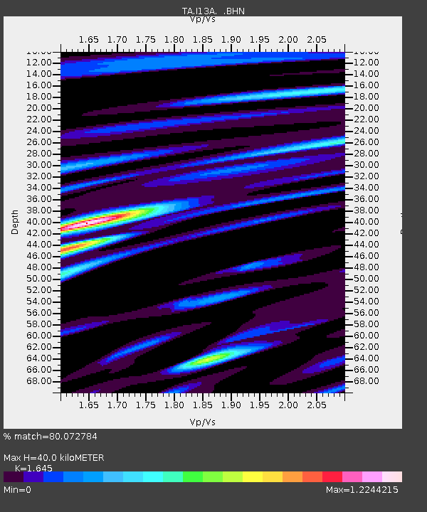
| Estimated Moho Depth: |
40.0 km |
| Estimated Crust Vp/Vs: |
1.64 |
| Assumed Crust Vp: |
6.291 km/s |
| Estimated Crust Vs: |
3.824 km/s |
| Estimated Crust Poisson's Ratio: |
0.21 |
|
| Radial Match: |
80.072784 % |
| Radial Bump: |
400 |
| Transverse Match: |
73.77238 % |
| Transverse Bump: |
400 |
| SOD ConfigId: |
2564 |
| Insert Time: |
2010-03-06 05:23:06.141 +0000 |
| GWidth: |
2.5 |
| Max Bumps: |
400 |
| Tol: |
0.001 |
|
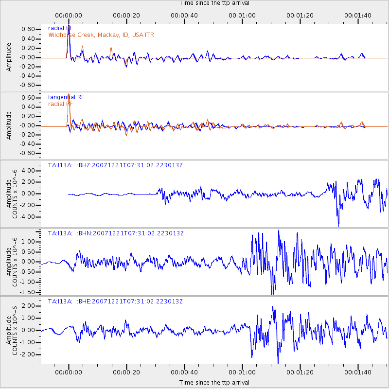
Signal To Noise
| Channel | StoN | STA | LTA |
| TA:I13A: :BHN:20071221T07:31:02.223013Z | 1.4680227 | 2.7890133E-7 | 1.8998435E-7 |
| TA:I13A: :BHE:20071221T07:31:02.223013Z | 2.6239357 | 4.1832013E-7 | 1.5942469E-7 |
| TA:I13A: :BHZ:20071221T07:31:02.223013Z | 5.93206 | 6.763122E-7 | 1.14009666E-7 |
| Arrivals |
| Ps | 4.4 SECOND |
| PpPs | 16 SECOND |
| PsPs/PpSs | 20 SECOND |


