You are here: Home > Network List > TA - USArray Transportable Network (new EarthScope stations) Stations List
> Station I13A Wildhorse Creek, Mackay, ID, USA > Earthquake Result Viewer
I13A Wildhorse Creek, Mackay, ID, USA - Earthquake Result Viewer
| Earthquake location: |
Windward Islands |
| Earthquake latitude/longitude: |
15.0/-61.3 |
| Earthquake time(UTC): |
2007/11/29 (333) 19:00:19 GMT |
| Earthquake Depth: |
148 km |
| Earthquake Magnitude: |
6.9 MB, 7.4 MW, 7.4 MW |
| Earthquake Catalog/Contributor: |
WHDF/NEIC |
|
| Network: |
TA USArray Transportable Network (new EarthScope stations) |
| Station: |
I13A Wildhorse Creek, Mackay, ID, USA |
| Lat/Lon: |
43.91 N/114.12 W |
| Elevation: |
2104 m |
|
| Distance: |
53.2 deg |
| Az: |
313.982 deg |
| Baz: |
105.788 deg |
| Ray Param: |
0.065762445 |
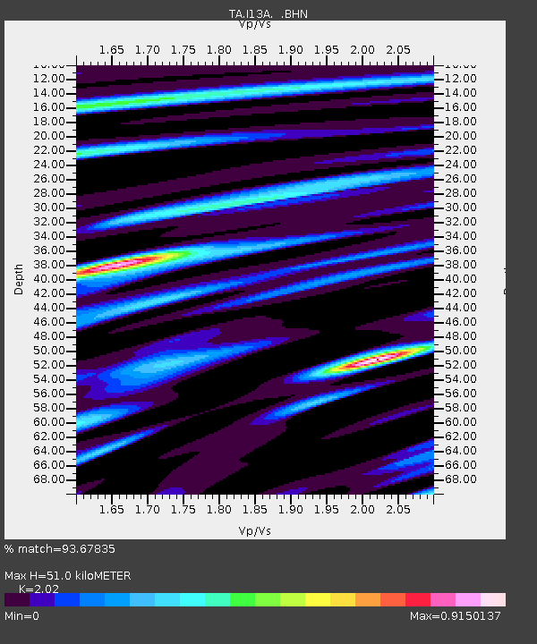
| Estimated Moho Depth: |
51.0 km |
| Estimated Crust Vp/Vs: |
2.02 |
| Assumed Crust Vp: |
6.291 km/s |
| Estimated Crust Vs: |
3.114 km/s |
| Estimated Crust Poisson's Ratio: |
0.34 |
|
| Radial Match: |
93.67835 % |
| Radial Bump: |
400 |
| Transverse Match: |
89.40785 % |
| Transverse Bump: |
400 |
| SOD ConfigId: |
2564 |
| Insert Time: |
2010-03-06 05:23:14.898 +0000 |
| GWidth: |
2.5 |
| Max Bumps: |
400 |
| Tol: |
0.001 |
|
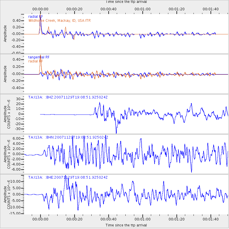
Signal To Noise
| Channel | StoN | STA | LTA |
| TA:I13A: :BHN:20071129T19:08:51.925024Z | 4.847535 | 1.159299E-6 | 2.3915229E-7 |
| TA:I13A: :BHE:20071129T19:08:51.925024Z | 11.6014595 | 3.256237E-6 | 2.8067475E-7 |
| TA:I13A: :BHZ:20071129T19:08:51.925024Z | 38.24516 | 8.597525E-6 | 2.2480035E-7 |
| Arrivals |
| Ps | 8.6 SECOND |
| PpPs | 23 SECOND |
| PsPs/PpSs | 32 SECOND |


