You are here: Home > Network List > CN - Canadian National Seismograph Network Stations List
> Station FRB IQALUIT, N.W.T. > Earthquake Result Viewer
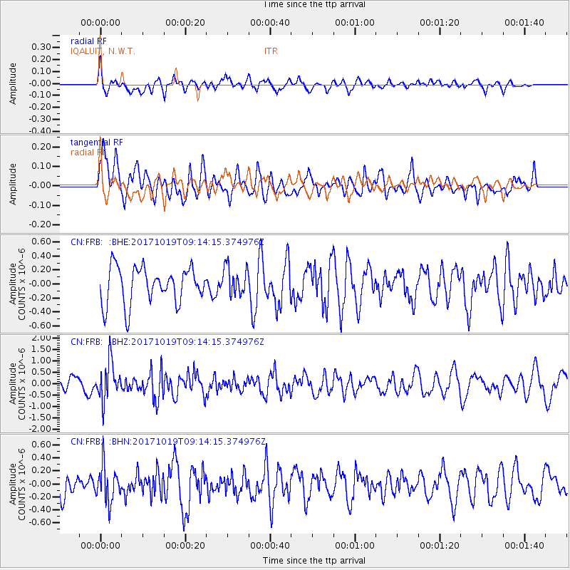
FRB IQALUIT, N.W.T. - Earthquake Result Viewer
*The percent match for this event was below the threshold and hence no stack was calculated.
| Earthquake location: |
Southeast Of Ryukyu Islands |
| Earthquake latitude/longitude: |
28.3/131.2 |
| Earthquake time(UTC): |
2017/10/19 (292) 09:02:01 GMT |
| Earthquake Depth: |
10 km |
| Earthquake Magnitude: |
5.8 Mww |
| Earthquake Catalog/Contributor: |
NEIC PDE/us |
|
| Network: |
CN Canadian National Seismograph Network |
| Station: |
FRB IQALUIT, N.W.T. |
| Lat/Lon: |
63.75 N/68.55 W |
| Elevation: |
18 m |
|
| Distance: |
86.9 deg |
| Az: |
8.655 deg |
| Baz: |
342.643 deg |
| Ray Param: |
$rayparam |
*The percent match for this event was below the threshold and hence was not used in the summary stack. |
|
| Radial Match: |
58.30863 % |
| Radial Bump: |
400 |
| Transverse Match: |
57.399185 % |
| Transverse Bump: |
400 |
| SOD ConfigId: |
13570011 |
| Insert Time: |
2019-04-29 00:14:22.412 +0000 |
| GWidth: |
2.5 |
| Max Bumps: |
400 |
| Tol: |
0.001 |
|
Signal To Noise
| Channel | StoN | STA | LTA |
| CN:FRB: :BHZ:20171019T09:14:15.374976Z | 2.391293 | 8.6796365E-7 | 3.629683E-7 |
| CN:FRB: :BHN:20171019T09:14:15.374976Z | 1.628588 | 2.8283335E-7 | 1.7366784E-7 |
| CN:FRB: :BHE:20171019T09:14:15.374976Z | 0.8103029 | 2.0915819E-7 | 2.5812346E-7 |
| Arrivals |
| Ps | |
| PpPs | |
| PsPs/PpSs | |


