You are here: Home > Network List > TA - USArray Transportable Network (new EarthScope stations) Stations List
> Station I13A Wildhorse Creek, Mackay, ID, USA > Earthquake Result Viewer
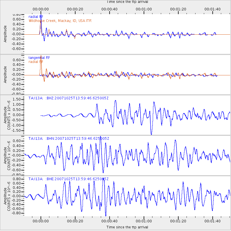
I13A Wildhorse Creek, Mackay, ID, USA - Earthquake Result Viewer

| Earthquake location: |
East Of Kuril Islands |
| Earthquake latitude/longitude: |
46.0/154.2 |
| Earthquake time(UTC): |
2007/10/25 (298) 13:50:02 GMT |
| Earthquake Depth: |
10 km |
| Earthquake Magnitude: |
6.0 MB, 5.7 MS, 6.1 MW, 5.9 MW |
| Earthquake Catalog/Contributor: |
WHDF/NEIC |
|
| Network: |
TA USArray Transportable Network (new EarthScope stations) |
| Station: |
I13A Wildhorse Creek, Mackay, ID, USA |
| Lat/Lon: |
43.91 N/114.12 W |
| Elevation: |
2104 m |
|
| Distance: |
61.2 deg |
| Az: |
55.49 deg |
| Baz: |
307.376 deg |
| Ray Param: |
0.06100051 |
| Estimated Moho Depth: |
32.5 km |
| Estimated Crust Vp/Vs: |
1.65 |
| Assumed Crust Vp: |
6.291 km/s |
| Estimated Crust Vs: |
3.813 km/s |
| Estimated Crust Poisson's Ratio: |
0.21 |
|
| Radial Match: |
93.728134 % |
| Radial Bump: |
371 |
| Transverse Match: |
77.30062 % |
| Transverse Bump: |
400 |
| SOD ConfigId: |
2564 |
| Insert Time: |
2010-03-06 05:23:27.978 +0000 |
| GWidth: |
2.5 |
| Max Bumps: |
400 |
| Tol: |
0.001 |
|
Signal To Noise
| Channel | StoN | STA | LTA |
| TA:I13A: :BHN:20071025T13:59:46.625005Z | 2.1894746 | 1.7437927E-7 | 7.9644344E-8 |
| TA:I13A: :BHE:20071025T13:59:46.625005Z | 4.70018 | 2.2212147E-7 | 4.725808E-8 |
| TA:I13A: :BHZ:20071025T13:59:46.625005Z | 5.555686 | 4.452563E-7 | 8.014425E-8 |
| Arrivals |
| Ps | 3.5 SECOND |
| PpPs | 13 SECOND |
| PsPs/PpSs | 17 SECOND |


