You are here: Home > Network List > TA - USArray Transportable Network (new EarthScope stations) Stations List
> Station F20K Avaraart Lake, AK, USA > Earthquake Result Viewer
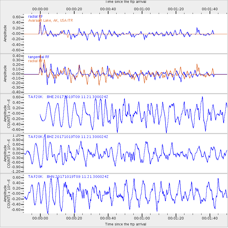
F20K Avaraart Lake, AK, USA - Earthquake Result Viewer
*The percent match for this event was below the threshold and hence no stack was calculated.
| Earthquake location: |
Southeast Of Ryukyu Islands |
| Earthquake latitude/longitude: |
28.3/131.2 |
| Earthquake time(UTC): |
2017/10/19 (292) 09:02:01 GMT |
| Earthquake Depth: |
10 km |
| Earthquake Magnitude: |
5.8 Mww |
| Earthquake Catalog/Contributor: |
NEIC PDE/us |
|
| Network: |
TA USArray Transportable Network (new EarthScope stations) |
| Station: |
F20K Avaraart Lake, AK, USA |
| Lat/Lon: |
67.05 N/155.73 W |
| Elevation: |
136 m |
|
| Distance: |
57.7 deg |
| Az: |
26.36 deg |
| Baz: |
266.537 deg |
| Ray Param: |
$rayparam |
*The percent match for this event was below the threshold and hence was not used in the summary stack. |
|
| Radial Match: |
58.280617 % |
| Radial Bump: |
400 |
| Transverse Match: |
59.485573 % |
| Transverse Bump: |
400 |
| SOD ConfigId: |
13570011 |
| Insert Time: |
2019-04-29 00:17:26.546 +0000 |
| GWidth: |
2.5 |
| Max Bumps: |
400 |
| Tol: |
0.001 |
|
Signal To Noise
| Channel | StoN | STA | LTA |
| TA:F20K: :BHZ:20171019T09:11:21.300024Z | 2.565849 | 7.1025937E-7 | 2.7681259E-7 |
| TA:F20K: :BHN:20171019T09:11:21.300024Z | 1.5690964 | 3.8244212E-7 | 2.4373398E-7 |
| TA:F20K: :BHE:20171019T09:11:21.300024Z | 1.1379548 | 3.5935503E-7 | 3.1579026E-7 |
| Arrivals |
| Ps | |
| PpPs | |
| PsPs/PpSs | |


