You are here: Home > Network List > CI - Caltech Regional Seismic Network Stations List
> Station SMM Simmler, CA, USA > Earthquake Result Viewer
SMM Simmler, CA, USA - Earthquake Result Viewer
*The percent match for this event was below the threshold and hence no stack was calculated.
| Earthquake location: |
Fiji Islands Region |
| Earthquake latitude/longitude: |
-17.9/-179.4 |
| Earthquake time(UTC): |
2009/08/16 (228) 22:03:09 GMT |
| Earthquake Depth: |
626 km |
| Earthquake Magnitude: |
5.5 MW, 4.9 MB |
| Earthquake Catalog/Contributor: |
WHDF/NEIC |
|
| Network: |
CI Caltech Regional Seismic Network |
| Station: |
SMM Simmler, CA, USA |
| Lat/Lon: |
35.31 N/120.00 W |
| Elevation: |
599 m |
|
| Distance: |
77.3 deg |
| Az: |
46.192 deg |
| Baz: |
237.147 deg |
| Ray Param: |
$rayparam |
*The percent match for this event was below the threshold and hence was not used in the summary stack. |
|
| Radial Match: |
55.16104 % |
| Radial Bump: |
400 |
| Transverse Match: |
50.104042 % |
| Transverse Bump: |
400 |
| SOD ConfigId: |
2622 |
| Insert Time: |
2010-02-26 01:32:36.688 +0000 |
| GWidth: |
2.5 |
| Max Bumps: |
400 |
| Tol: |
0.001 |
|
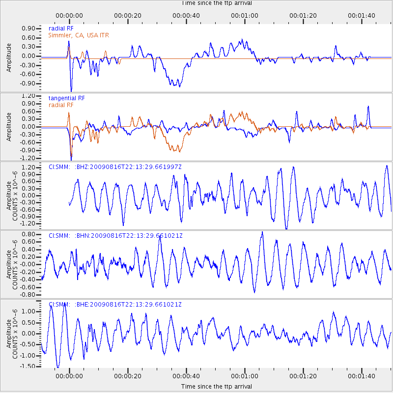
Signal To Noise
| Channel | StoN | STA | LTA |
| CI:SMM: :BHN:20090816T22:13:29.661021Z | 0.80809367 | 1.9659657E-7 | 2.4328438E-7 |
| CI:SMM: :BHE:20090816T22:13:29.661021Z | 0.84900963 | 7.235677E-7 | 8.522492E-7 |
| CI:SMM: :BHZ:20090816T22:13:29.661997Z | 0.7253819 | 3.3209832E-7 | 4.578255E-7 |
| Arrivals |
| Ps | |
| PpPs | |
| PsPs/PpSs | |


