You are here: Home > Network List > NM - Cooperative New Madrid Seismic Network Stations List
> Station CGM3 Cape Girardeau, MO > Earthquake Result Viewer
CGM3 Cape Girardeau, MO - Earthquake Result Viewer
| Earthquake location: |
Leeward Islands |
| Earthquake latitude/longitude: |
18.0/-60.7 |
| Earthquake time(UTC): |
2016/03/19 (079) 11:26:34 GMT |
| Earthquake Depth: |
32 km |
| Earthquake Magnitude: |
6.0 MWW, 5.9 MWB |
| Earthquake Catalog/Contributor: |
NEIC PDE/NEIC COMCAT |
|
| Network: |
NM Cooperative New Madrid Seismic Network |
| Station: |
CGM3 Cape Girardeau, MO |
| Lat/Lon: |
37.30 N/89.66 W |
| Elevation: |
148 m |
|
| Distance: |
31.9 deg |
| Az: |
312.999 deg |
| Baz: |
119.21 deg |
| Ray Param: |
0.078847736 |
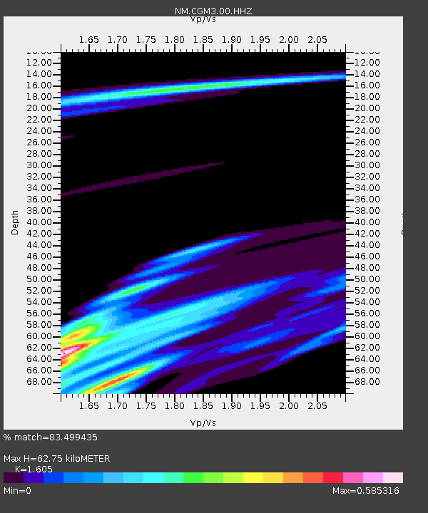
| Estimated Moho Depth: |
62.75 km |
| Estimated Crust Vp/Vs: |
1.61 |
| Assumed Crust Vp: |
6.444 km/s |
| Estimated Crust Vs: |
4.015 km/s |
| Estimated Crust Poisson's Ratio: |
0.18 |
|
| Radial Match: |
83.499435 % |
| Radial Bump: |
400 |
| Transverse Match: |
57.053513 % |
| Transverse Bump: |
400 |
| SOD ConfigId: |
1464191 |
| Insert Time: |
2016-04-02 12:05:43.473 +0000 |
| GWidth: |
2.5 |
| Max Bumps: |
400 |
| Tol: |
0.001 |
|

Signal To Noise
| Channel | StoN | STA | LTA |
| NM:CGM3:00:HHZ:20160319T11:32:25.819011Z | 7.641478 | 1.1385965E-6 | 1.4900213E-7 |
| NM:CGM3:00:HHN:20160319T11:32:25.819011Z | 2.798472 | 3.6008242E-7 | 1.2867109E-7 |
| NM:CGM3:00:HHE:20160319T11:32:25.819011Z | 4.188376 | 4.6371886E-7 | 1.10715675E-7 |
| Arrivals |
| Ps | 6.4 SECOND |
| PpPs | 23 SECOND |
| PsPs/PpSs | 30 SECOND |


