You are here: Home > Network List > TA - USArray Transportable Network (new EarthScope stations) Stations List
> Station N23A Red Feather Lakes, CO, USA > Earthquake Result Viewer
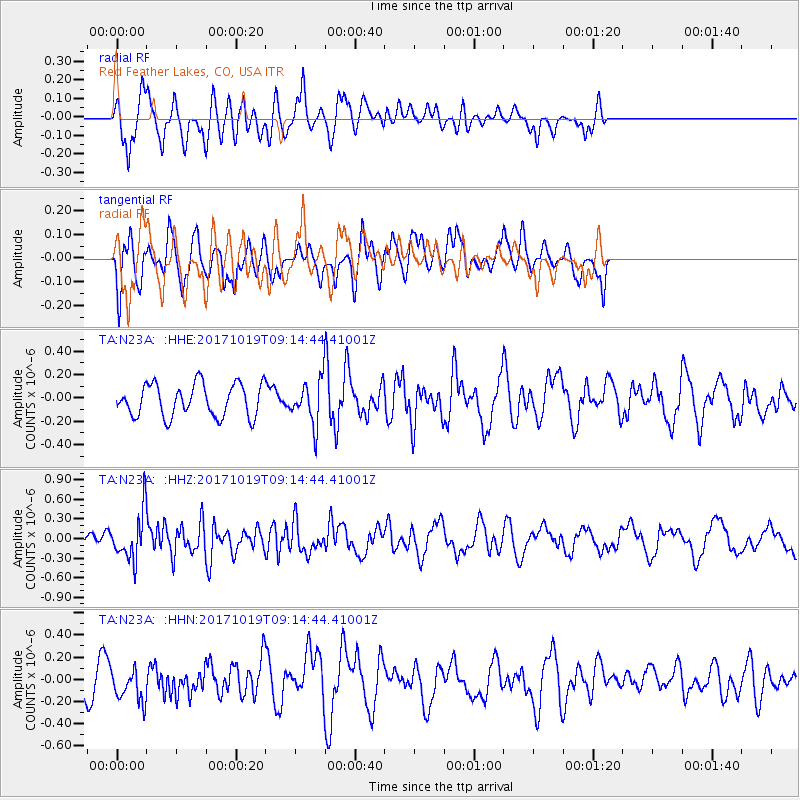
N23A Red Feather Lakes, CO, USA - Earthquake Result Viewer
*The percent match for this event was below the threshold and hence no stack was calculated.
| Earthquake location: |
Southeast Of Ryukyu Islands |
| Earthquake latitude/longitude: |
28.3/131.2 |
| Earthquake time(UTC): |
2017/10/19 (292) 09:02:01 GMT |
| Earthquake Depth: |
10 km |
| Earthquake Magnitude: |
5.8 Mww |
| Earthquake Catalog/Contributor: |
NEIC PDE/us |
|
| Network: |
TA USArray Transportable Network (new EarthScope stations) |
| Station: |
N23A Red Feather Lakes, CO, USA |
| Lat/Lon: |
40.89 N/105.94 W |
| Elevation: |
2458 m |
|
| Distance: |
93.1 deg |
| Az: |
39.627 deg |
| Baz: |
312.121 deg |
| Ray Param: |
$rayparam |
*The percent match for this event was below the threshold and hence was not used in the summary stack. |
|
| Radial Match: |
56.160103 % |
| Radial Bump: |
389 |
| Transverse Match: |
68.686485 % |
| Transverse Bump: |
400 |
| SOD ConfigId: |
13570011 |
| Insert Time: |
2019-04-29 00:18:01.304 +0000 |
| GWidth: |
2.5 |
| Max Bumps: |
400 |
| Tol: |
0.001 |
|
Signal To Noise
| Channel | StoN | STA | LTA |
| TA:N23A: :HHZ:20171019T09:14:44.41001Z | 2.2062917 | 3.6088193E-7 | 1.6356944E-7 |
| TA:N23A: :HHN:20171019T09:14:44.41001Z | 1.2259207 | 1.5007754E-7 | 1.2242027E-7 |
| TA:N23A: :HHE:20171019T09:14:44.41001Z | 1.2852929 | 1.7754033E-7 | 1.3813221E-7 |
| Arrivals |
| Ps | |
| PpPs | |
| PsPs/PpSs | |


