You are here: Home > Network List > TA - USArray Transportable Network (new EarthScope stations) Stations List
> Station I13A Wildhorse Creek, Mackay, ID, USA > Earthquake Result Viewer
I13A Wildhorse Creek, Mackay, ID, USA - Earthquake Result Viewer
| Earthquake location: |
Northern Mid-Atlantic Ridge |
| Earthquake latitude/longitude: |
52.4/-31.8 |
| Earthquake time(UTC): |
2007/05/23 (143) 04:41:46 GMT |
| Earthquake Depth: |
10 km |
| Earthquake Magnitude: |
5.6 MS, 5.4 MB, 5.7 MW, 5.6 MW |
| Earthquake Catalog/Contributor: |
WHDF/NEIC |
|
| Network: |
TA USArray Transportable Network (new EarthScope stations) |
| Station: |
I13A Wildhorse Creek, Mackay, ID, USA |
| Lat/Lon: |
43.91 N/114.12 W |
| Elevation: |
2104 m |
|
| Distance: |
52.8 deg |
| Az: |
295.883 deg |
| Baz: |
49.782 deg |
| Ray Param: |
0.06655764 |
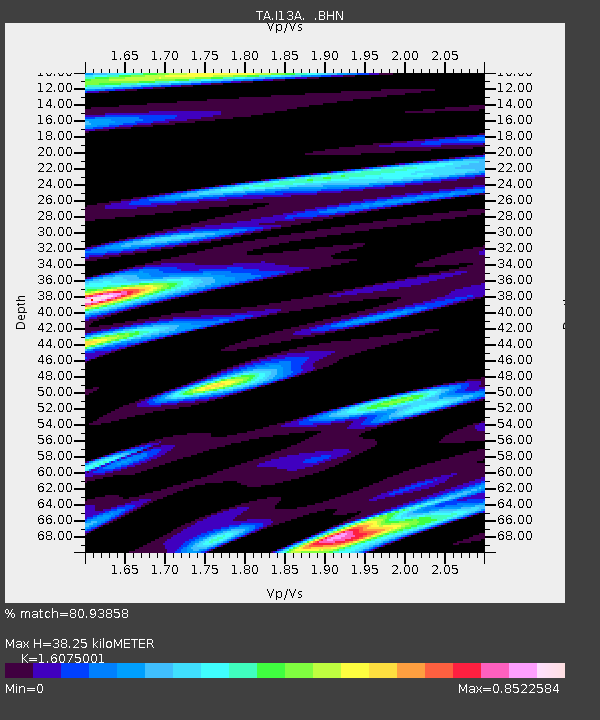
| Estimated Moho Depth: |
38.25 km |
| Estimated Crust Vp/Vs: |
1.61 |
| Assumed Crust Vp: |
6.291 km/s |
| Estimated Crust Vs: |
3.914 km/s |
| Estimated Crust Poisson's Ratio: |
0.18 |
|
| Radial Match: |
80.93858 % |
| Radial Bump: |
400 |
| Transverse Match: |
71.43308 % |
| Transverse Bump: |
400 |
| SOD ConfigId: |
2564 |
| Insert Time: |
2010-03-06 05:24:33.850 +0000 |
| GWidth: |
2.5 |
| Max Bumps: |
400 |
| Tol: |
0.001 |
|

Signal To Noise
| Channel | StoN | STA | LTA |
| TA:I13A: :BHN:20070523T04:50:30.524009Z | 2.0223258 | 1.3470935E-7 | 6.66111E-8 |
| TA:I13A: :BHE:20070523T04:50:30.524009Z | 4.137944 | 1.8449835E-7 | 4.4586958E-8 |
| TA:I13A: :BHZ:20070523T04:50:30.524009Z | 9.835375 | 4.829244E-7 | 4.9100763E-8 |
| Arrivals |
| Ps | 3.9 SECOND |
| PpPs | 15 SECOND |
| PsPs/PpSs | 19 SECOND |


