You are here: Home > Network List > TA - USArray Transportable Network (new EarthScope stations) Stations List
> Station E18K Tukpahlearik Creek, AK, USA > Earthquake Result Viewer
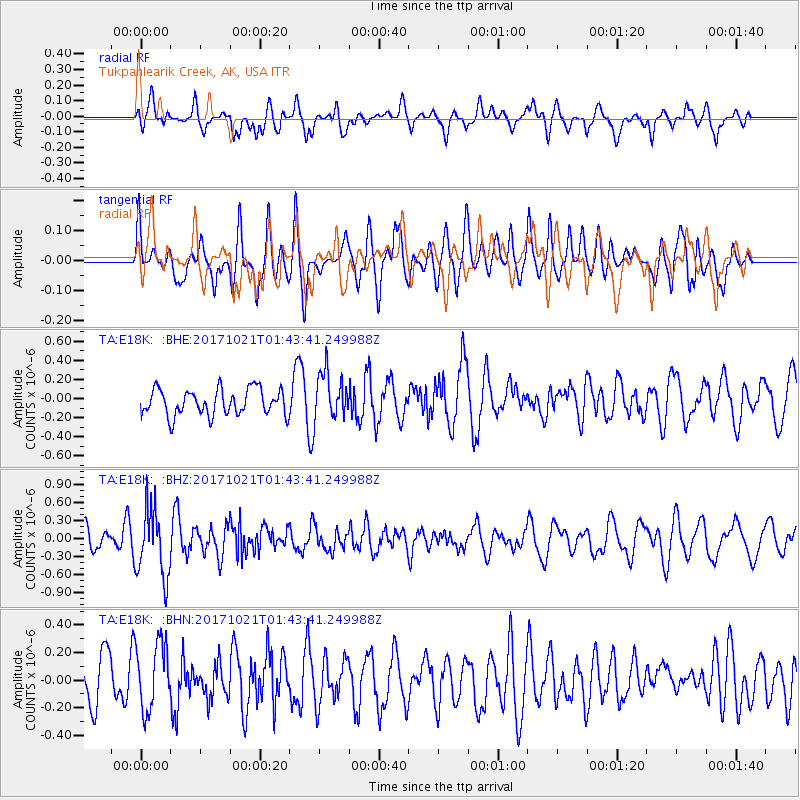
E18K Tukpahlearik Creek, AK, USA - Earthquake Result Viewer
*The percent match for this event was below the threshold and hence no stack was calculated.
| Earthquake location: |
Talaud Islands, Indonesia |
| Earthquake latitude/longitude: |
4.1/127.9 |
| Earthquake time(UTC): |
2017/10/21 (294) 01:32:14 GMT |
| Earthquake Depth: |
62 km |
| Earthquake Magnitude: |
5.3 Mww |
| Earthquake Catalog/Contributor: |
NEIC PDE/us |
|
| Network: |
TA USArray Transportable Network (new EarthScope stations) |
| Station: |
E18K Tukpahlearik Creek, AK, USA |
| Lat/Lon: |
67.42 N/160.60 W |
| Elevation: |
297 m |
|
| Distance: |
79.2 deg |
| Az: |
21.895 deg |
| Baz: |
254.413 deg |
| Ray Param: |
$rayparam |
*The percent match for this event was below the threshold and hence was not used in the summary stack. |
|
| Radial Match: |
58.541157 % |
| Radial Bump: |
400 |
| Transverse Match: |
55.59617 % |
| Transverse Bump: |
400 |
| SOD ConfigId: |
13570011 |
| Insert Time: |
2019-04-29 00:21:56.007 +0000 |
| GWidth: |
2.5 |
| Max Bumps: |
400 |
| Tol: |
0.001 |
|
Signal To Noise
| Channel | StoN | STA | LTA |
| TA:E18K: :BHZ:20171021T01:43:41.249988Z | 2.5597947 | 5.702242E-7 | 2.2276168E-7 |
| TA:E18K: :BHN:20171021T01:43:41.249988Z | 1.6196424 | 2.442037E-7 | 1.5077632E-7 |
| TA:E18K: :BHE:20171021T01:43:41.249988Z | 1.7203 | 2.3466755E-7 | 1.3641083E-7 |
| Arrivals |
| Ps | |
| PpPs | |
| PsPs/PpSs | |


