You are here: Home > Network List > TA - USArray Transportable Network (new EarthScope stations) Stations List
> Station G23K Bananza Creek, AK, USA > Earthquake Result Viewer
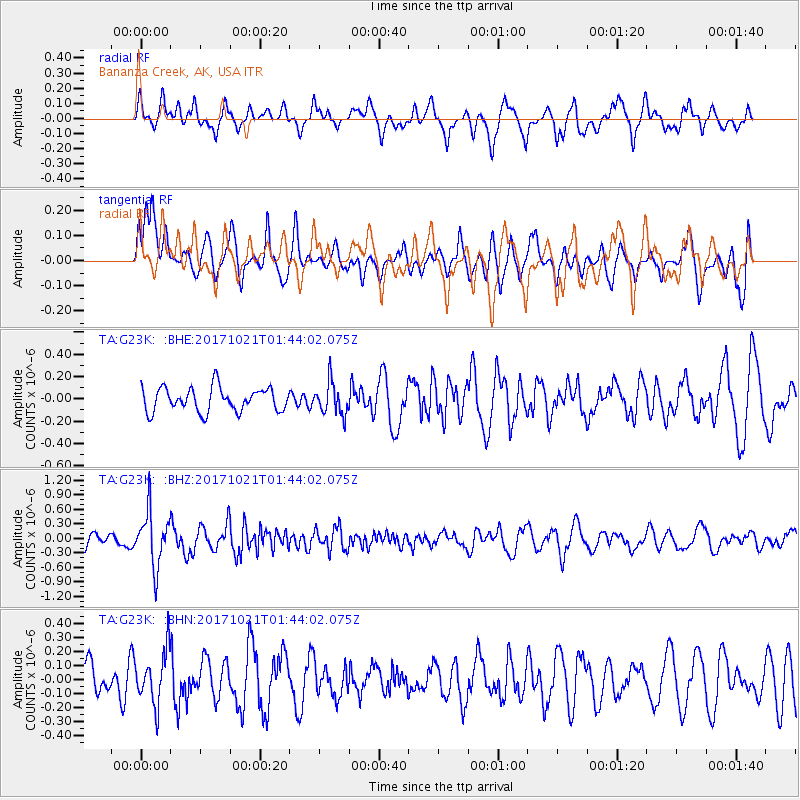
G23K Bananza Creek, AK, USA - Earthquake Result Viewer
*The percent match for this event was below the threshold and hence no stack was calculated.
| Earthquake location: |
Talaud Islands, Indonesia |
| Earthquake latitude/longitude: |
4.1/127.9 |
| Earthquake time(UTC): |
2017/10/21 (294) 01:32:14 GMT |
| Earthquake Depth: |
62 km |
| Earthquake Magnitude: |
5.3 Mww |
| Earthquake Catalog/Contributor: |
NEIC PDE/us |
|
| Network: |
TA USArray Transportable Network (new EarthScope stations) |
| Station: |
G23K Bananza Creek, AK, USA |
| Lat/Lon: |
66.71 N/150.02 W |
| Elevation: |
746 m |
|
| Distance: |
83.1 deg |
| Az: |
23.373 deg |
| Baz: |
264.378 deg |
| Ray Param: |
$rayparam |
*The percent match for this event was below the threshold and hence was not used in the summary stack. |
|
| Radial Match: |
66.507706 % |
| Radial Bump: |
400 |
| Transverse Match: |
63.68971 % |
| Transverse Bump: |
400 |
| SOD ConfigId: |
13570011 |
| Insert Time: |
2019-04-29 00:22:03.364 +0000 |
| GWidth: |
2.5 |
| Max Bumps: |
400 |
| Tol: |
0.001 |
|
Signal To Noise
| Channel | StoN | STA | LTA |
| TA:G23K: :BHZ:20171021T01:44:02.075Z | 3.8311763 | 5.5890604E-7 | 1.4588367E-7 |
| TA:G23K: :BHN:20171021T01:44:02.075Z | 1.2661996 | 1.8645272E-7 | 1.4725383E-7 |
| TA:G23K: :BHE:20171021T01:44:02.075Z | 1.346899 | 1.4226018E-7 | 1.05620515E-7 |
| Arrivals |
| Ps | |
| PpPs | |
| PsPs/PpSs | |


