You are here: Home > Network List > TA - USArray Transportable Network (new EarthScope stations) Stations List
> Station I23K Minto, Yukon-Koyukuk, AK, USA > Earthquake Result Viewer
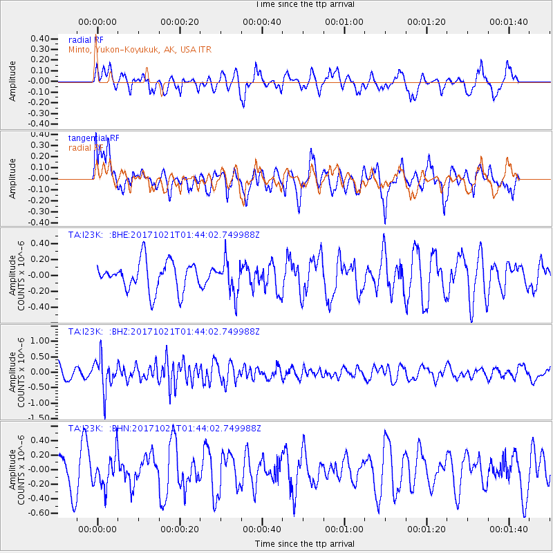
I23K Minto, Yukon-Koyukuk, AK, USA - Earthquake Result Viewer
*The percent match for this event was below the threshold and hence no stack was calculated.
| Earthquake location: |
Talaud Islands, Indonesia |
| Earthquake latitude/longitude: |
4.1/127.9 |
| Earthquake time(UTC): |
2017/10/21 (294) 01:32:14 GMT |
| Earthquake Depth: |
62 km |
| Earthquake Magnitude: |
5.3 Mww |
| Earthquake Catalog/Contributor: |
NEIC PDE/us |
|
| Network: |
TA USArray Transportable Network (new EarthScope stations) |
| Station: |
I23K Minto, Yukon-Koyukuk, AK, USA |
| Lat/Lon: |
65.15 N/149.36 W |
| Elevation: |
149 m |
|
| Distance: |
83.2 deg |
| Az: |
24.973 deg |
| Baz: |
265.173 deg |
| Ray Param: |
$rayparam |
*The percent match for this event was below the threshold and hence was not used in the summary stack. |
|
| Radial Match: |
53.87024 % |
| Radial Bump: |
369 |
| Transverse Match: |
50.028183 % |
| Transverse Bump: |
400 |
| SOD ConfigId: |
13570011 |
| Insert Time: |
2019-04-29 00:22:08.752 +0000 |
| GWidth: |
2.5 |
| Max Bumps: |
400 |
| Tol: |
0.001 |
|
Signal To Noise
| Channel | StoN | STA | LTA |
| TA:I23K: :BHZ:20171021T01:44:02.749988Z | 3.519987 | 5.1540724E-7 | 1.4642305E-7 |
| TA:I23K: :BHN:20171021T01:44:02.749988Z | 0.70542926 | 2.196349E-7 | 3.1134928E-7 |
| TA:I23K: :BHE:20171021T01:44:02.749988Z | 1.1555852 | 2.0904274E-7 | 1.8089773E-7 |
| Arrivals |
| Ps | |
| PpPs | |
| PsPs/PpSs | |


