You are here: Home > Network List > TA - USArray Transportable Network (new EarthScope stations) Stations List
> Station I13A Wildhorse Creek, Mackay, ID, USA > Earthquake Result Viewer
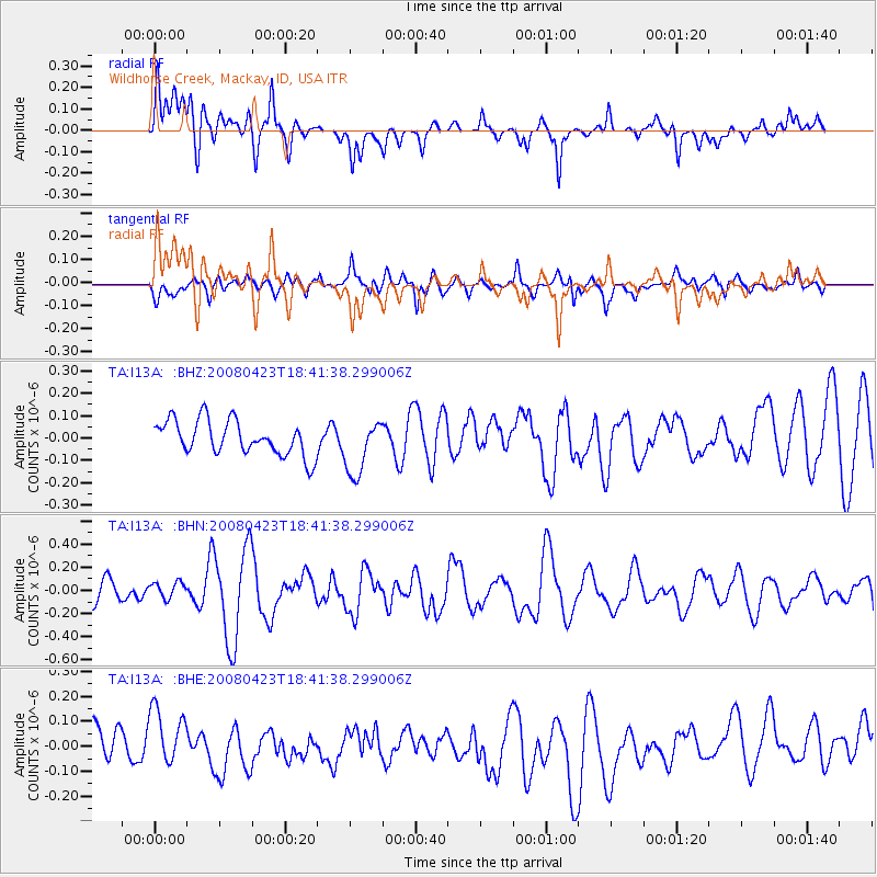
I13A Wildhorse Creek, Mackay, ID, USA - Earthquake Result Viewer
*The percent match for this event was below the threshold and hence no stack was calculated.
| Earthquake location: |
Taiwan Region |
| Earthquake latitude/longitude: |
22.9/121.6 |
| Earthquake time(UTC): |
2008/04/23 (114) 18:28:41 GMT |
| Earthquake Depth: |
10 km |
| Earthquake Magnitude: |
5.6 MB, 5.9 MS, 6.0 MW, 6.0 MW |
| Earthquake Catalog/Contributor: |
WHDF/NEIC |
|
| Network: |
TA USArray Transportable Network (new EarthScope stations) |
| Station: |
I13A Wildhorse Creek, Mackay, ID, USA |
| Lat/Lon: |
43.91 N/114.12 W |
| Elevation: |
2104 m |
|
| Distance: |
96.2 deg |
| Az: |
36.927 deg |
| Baz: |
309.943 deg |
| Ray Param: |
$rayparam |
*The percent match for this event was below the threshold and hence was not used in the summary stack. |
|
| Radial Match: |
60.54587 % |
| Radial Bump: |
400 |
| Transverse Match: |
56.829536 % |
| Transverse Bump: |
400 |
| SOD ConfigId: |
2504 |
| Insert Time: |
2010-03-06 05:25:24.142 +0000 |
| GWidth: |
2.5 |
| Max Bumps: |
400 |
| Tol: |
0.001 |
|
Signal To Noise
| Channel | StoN | STA | LTA |
| TA:I13A: :BHN:20080423T18:41:38.299006Z | 0.92605126 | 6.948807E-8 | 7.503696E-8 |
| TA:I13A: :BHE:20080423T18:41:38.299006Z | 1.8298744 | 1.180461E-7 | 6.4510495E-8 |
| TA:I13A: :BHZ:20080423T18:41:38.299006Z | 1.5967097 | 1.229586E-7 | 7.7007485E-8 |
| Arrivals |
| Ps | |
| PpPs | |
| PsPs/PpSs | |


