You are here: Home > Network List > US - United States National Seismic Network Stations List
> Station DUG Dugway, Tooele County, Utah, USA > Earthquake Result Viewer
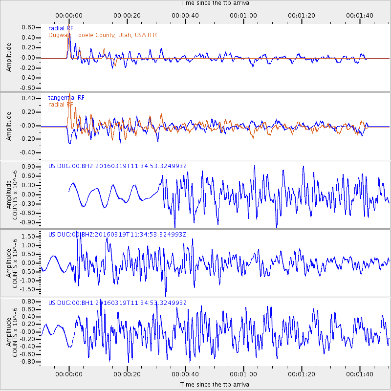
DUG Dugway, Tooele County, Utah, USA - Earthquake Result Viewer
*The percent match for this event was below the threshold and hence no stack was calculated.
| Earthquake location: |
Leeward Islands |
| Earthquake latitude/longitude: |
18.0/-60.7 |
| Earthquake time(UTC): |
2016/03/19 (079) 11:26:34 GMT |
| Earthquake Depth: |
32 km |
| Earthquake Magnitude: |
6.0 MWW, 5.9 MWB |
| Earthquake Catalog/Contributor: |
NEIC PDE/NEIC COMCAT |
|
| Network: |
US United States National Seismic Network |
| Station: |
DUG Dugway, Tooele County, Utah, USA |
| Lat/Lon: |
40.19 N/112.81 W |
| Elevation: |
1477 m |
|
| Distance: |
49.8 deg |
| Az: |
307.71 deg |
| Baz: |
100.6 deg |
| Ray Param: |
$rayparam |
*The percent match for this event was below the threshold and hence was not used in the summary stack. |
|
| Radial Match: |
75.16132 % |
| Radial Bump: |
400 |
| Transverse Match: |
66.648155 % |
| Transverse Bump: |
400 |
| SOD ConfigId: |
1464191 |
| Insert Time: |
2016-04-02 12:07:29.710 +0000 |
| GWidth: |
2.5 |
| Max Bumps: |
400 |
| Tol: |
0.001 |
|
Signal To Noise
| Channel | StoN | STA | LTA |
| US:DUG:00:BHZ:20160319T11:34:53.324993Z | 3.1977017 | 7.6361886E-7 | 2.388024E-7 |
| US:DUG:00:BH1:20160319T11:34:53.324993Z | 2.7218173 | 2.788213E-7 | 1.0243939E-7 |
| US:DUG:00:BH2:20160319T11:34:53.324993Z | 1.430182 | 3.1892407E-7 | 2.2299544E-7 |
| Arrivals |
| Ps | |
| PpPs | |
| PsPs/PpSs | |


