You are here: Home > Network List > CI - Caltech Regional Seismic Network Stations List
> Station SMM Simmler, CA, USA > Earthquake Result Viewer
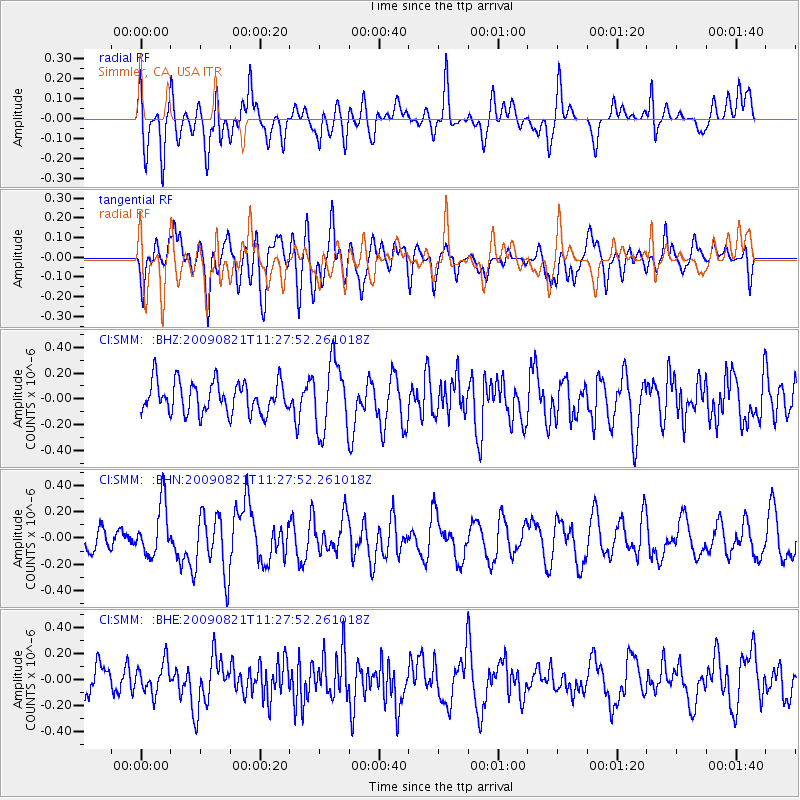
SMM Simmler, CA, USA - Earthquake Result Viewer
*The percent match for this event was below the threshold and hence no stack was calculated.
| Earthquake location: |
Southeast Of Loyalty Islands |
| Earthquake latitude/longitude: |
-22.5/171.2 |
| Earthquake time(UTC): |
2009/08/21 (233) 11:15:39 GMT |
| Earthquake Depth: |
10 km |
| Earthquake Magnitude: |
5.7 MW, 5.2 MS, 5.2 MB, 5.6 MW |
| Earthquake Catalog/Contributor: |
WHDF/NEIC |
|
| Network: |
CI Caltech Regional Seismic Network |
| Station: |
SMM Simmler, CA, USA |
| Lat/Lon: |
35.31 N/120.00 W |
| Elevation: |
599 m |
|
| Distance: |
86.9 deg |
| Az: |
49.767 deg |
| Baz: |
239.659 deg |
| Ray Param: |
$rayparam |
*The percent match for this event was below the threshold and hence was not used in the summary stack. |
|
| Radial Match: |
47.60926 % |
| Radial Bump: |
400 |
| Transverse Match: |
59.77426 % |
| Transverse Bump: |
400 |
| SOD ConfigId: |
2622 |
| Insert Time: |
2010-02-26 01:32:41.032 +0000 |
| GWidth: |
2.5 |
| Max Bumps: |
400 |
| Tol: |
0.001 |
|
Signal To Noise
| Channel | StoN | STA | LTA |
| CI:SMM: :BHN:20090821T11:27:52.261018Z | 1.995108 | 1.9706441E-7 | 9.87738E-8 |
| CI:SMM: :BHE:20090821T11:27:52.261018Z | 0.7755761 | 1.15358866E-7 | 1.4873959E-7 |
| CI:SMM: :BHZ:20090821T11:27:52.261018Z | 2.1907618 | 2.6595174E-7 | 1.2139692E-7 |
| Arrivals |
| Ps | |
| PpPs | |
| PsPs/PpSs | |


