You are here: Home > Network List > US - United States National Seismic Network Stations List
> Station GLMI Grayling, Michigan, USA > Earthquake Result Viewer
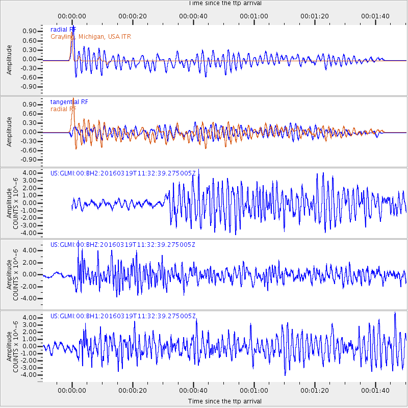
GLMI Grayling, Michigan, USA - Earthquake Result Viewer
*The percent match for this event was below the threshold and hence no stack was calculated.
| Earthquake location: |
Leeward Islands |
| Earthquake latitude/longitude: |
18.0/-60.7 |
| Earthquake time(UTC): |
2016/03/19 (079) 11:26:34 GMT |
| Earthquake Depth: |
32 km |
| Earthquake Magnitude: |
6.0 MWW, 5.9 MWB |
| Earthquake Catalog/Contributor: |
NEIC PDE/NEIC COMCAT |
|
| Network: |
US United States National Seismic Network |
| Station: |
GLMI Grayling, Michigan, USA |
| Lat/Lon: |
44.82 N/84.62 W |
| Elevation: |
387 m |
|
| Distance: |
33.4 deg |
| Az: |
328.397 deg |
| Baz: |
135.508 deg |
| Ray Param: |
$rayparam |
*The percent match for this event was below the threshold and hence was not used in the summary stack. |
|
| Radial Match: |
79.89843 % |
| Radial Bump: |
400 |
| Transverse Match: |
71.060715 % |
| Transverse Bump: |
400 |
| SOD ConfigId: |
1464191 |
| Insert Time: |
2016-04-02 12:07:48.452 +0000 |
| GWidth: |
2.5 |
| Max Bumps: |
400 |
| Tol: |
0.001 |
|
Signal To Noise
| Channel | StoN | STA | LTA |
| US:GLMI:00:BHZ:20160319T11:32:39.275005Z | 7.7367487 | 1.7840235E-6 | 2.3059087E-7 |
| US:GLMI:00:BH1:20160319T11:32:39.275005Z | 3.1360838 | 1.1017727E-6 | 3.5132115E-7 |
| US:GLMI:00:BH2:20160319T11:32:39.275005Z | 3.5152917 | 1.337295E-6 | 3.804222E-7 |
| Arrivals |
| Ps | |
| PpPs | |
| PsPs/PpSs | |


