You are here: Home > Network List > AK - Alaska Regional Network Stations List
> Station CUT Chulitna, AK, USA > Earthquake Result Viewer
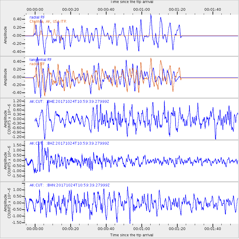
CUT Chulitna, AK, USA - Earthquake Result Viewer
*The percent match for this event was below the threshold and hence no stack was calculated.
| Earthquake location: |
Banda Sea |
| Earthquake latitude/longitude: |
-7.2/123.0 |
| Earthquake time(UTC): |
2017/10/24 (297) 10:47:47 GMT |
| Earthquake Depth: |
549 km |
| Earthquake Magnitude: |
6.7 Mww |
| Earthquake Catalog/Contributor: |
NEIC PDE/us |
|
| Network: |
AK Alaska Regional Network |
| Station: |
CUT Chulitna, AK, USA |
| Lat/Lon: |
62.41 N/150.26 W |
| Elevation: |
574 m |
|
| Distance: |
94.8 deg |
| Az: |
27.81 deg |
| Baz: |
263.729 deg |
| Ray Param: |
$rayparam |
*The percent match for this event was below the threshold and hence was not used in the summary stack. |
|
| Radial Match: |
55.451454 % |
| Radial Bump: |
400 |
| Transverse Match: |
68.336685 % |
| Transverse Bump: |
400 |
| SOD ConfigId: |
13570011 |
| Insert Time: |
2019-04-29 00:26:12.761 +0000 |
| GWidth: |
2.5 |
| Max Bumps: |
400 |
| Tol: |
0.001 |
|
Signal To Noise
| Channel | StoN | STA | LTA |
| AK:CUT: :BHZ:20171024T10:59:39.27999Z | 5.989465 | 9.3700777E-7 | 1.5644264E-7 |
| AK:CUT: :BHN:20171024T10:59:39.27999Z | 1.0161994 | 4.1951205E-7 | 4.1282456E-7 |
| AK:CUT: :BHE:20171024T10:59:39.27999Z | 1.1885494 | 5.0459323E-7 | 4.2454545E-7 |
| Arrivals |
| Ps | |
| PpPs | |
| PsPs/PpSs | |


