You are here: Home > Network List > TA - USArray Transportable Network (new EarthScope stations) Stations List
> Station I13A Wildhorse Creek, Mackay, ID, USA > Earthquake Result Viewer
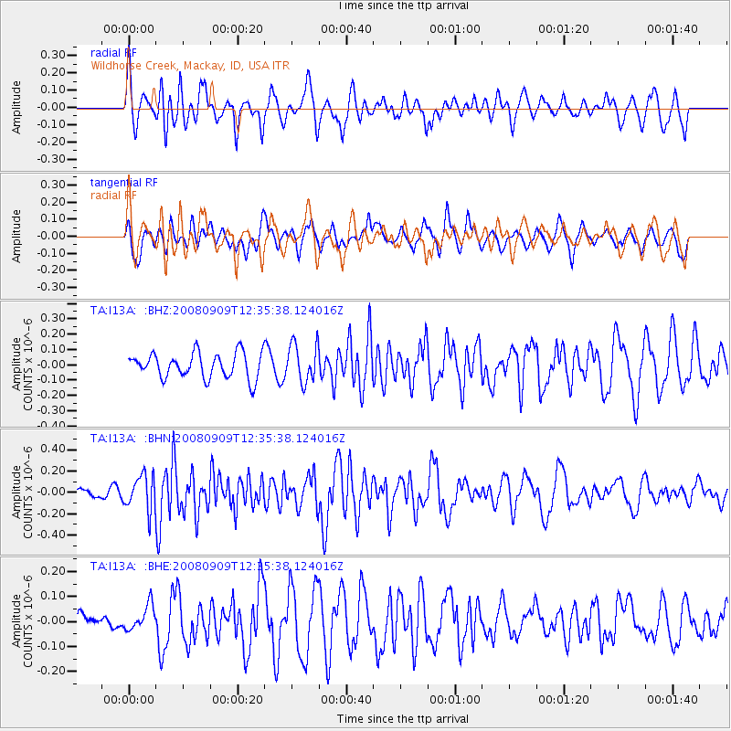
I13A Wildhorse Creek, Mackay, ID, USA - Earthquake Result Viewer
*The percent match for this event was below the threshold and hence no stack was calculated.
| Earthquake location: |
Solomon Islands |
| Earthquake latitude/longitude: |
-9.3/158.3 |
| Earthquake time(UTC): |
2008/09/09 (253) 12:22:49 GMT |
| Earthquake Depth: |
12 km |
| Earthquake Magnitude: |
5.7 MB, 5.6 MS, 5.9 MW, 5.9 MW |
| Earthquake Catalog/Contributor: |
WHDF/NEIC |
|
| Network: |
TA USArray Transportable Network (new EarthScope stations) |
| Station: |
I13A Wildhorse Creek, Mackay, ID, USA |
| Lat/Lon: |
43.91 N/114.12 W |
| Elevation: |
2104 m |
|
| Distance: |
94.6 deg |
| Az: |
46.424 deg |
| Baz: |
261.694 deg |
| Ray Param: |
$rayparam |
*The percent match for this event was below the threshold and hence was not used in the summary stack. |
|
| Radial Match: |
58.766914 % |
| Radial Bump: |
400 |
| Transverse Match: |
51.32605 % |
| Transverse Bump: |
400 |
| SOD ConfigId: |
2560 |
| Insert Time: |
2010-03-06 05:25:51.374 +0000 |
| GWidth: |
2.5 |
| Max Bumps: |
400 |
| Tol: |
0.001 |
|
Signal To Noise
| Channel | StoN | STA | LTA |
| TA:I13A: :BHN:20080909T12:35:38.124016Z | 2.5517616 | 1.62797E-7 | 6.3797884E-8 |
| TA:I13A: :BHE:20080909T12:35:38.124016Z | 0.8701055 | 5.0140283E-8 | 5.762552E-8 |
| TA:I13A: :BHZ:20080909T12:35:38.124016Z | 1.5297565 | 1.2603812E-7 | 8.239096E-8 |
| Arrivals |
| Ps | |
| PpPs | |
| PsPs/PpSs | |


