You are here: Home > Network List > AV - Alaska Volcano Observatory Stations List
> Station SPCR Ckakachatna River, Mount Spurr, Alaska > Earthquake Result Viewer
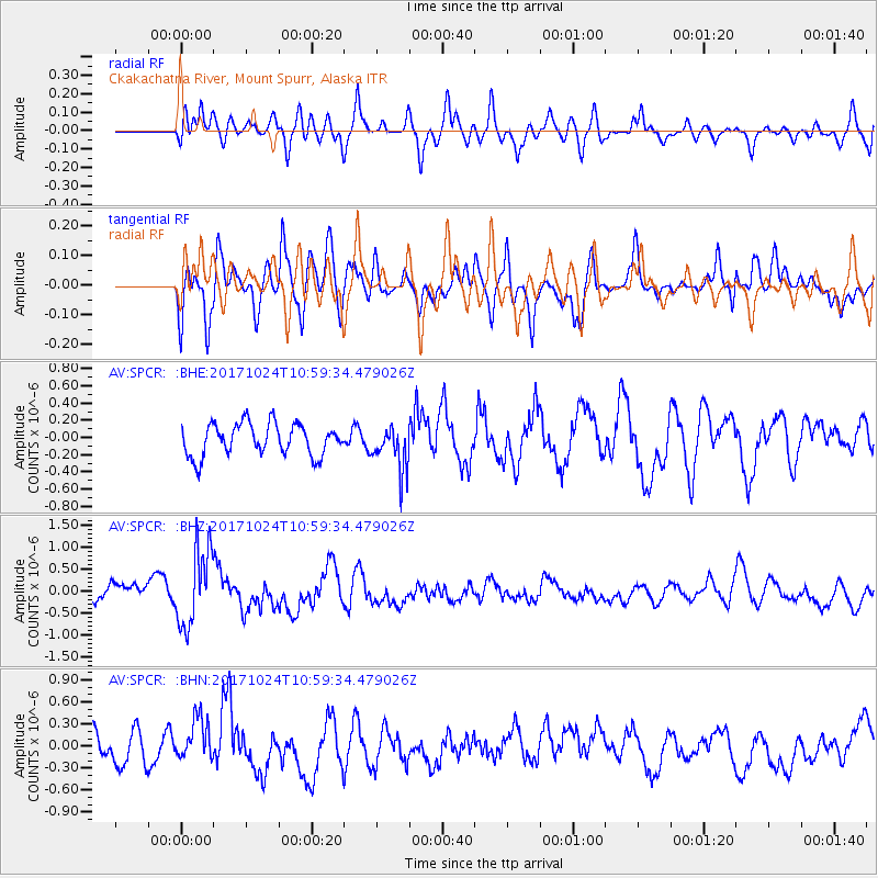
SPCR Ckakachatna River, Mount Spurr, Alaska - Earthquake Result Viewer
*The percent match for this event was below the threshold and hence no stack was calculated.
| Earthquake location: |
Banda Sea |
| Earthquake latitude/longitude: |
-7.2/123.0 |
| Earthquake time(UTC): |
2017/10/24 (297) 10:47:47 GMT |
| Earthquake Depth: |
549 km |
| Earthquake Magnitude: |
6.7 Mww |
| Earthquake Catalog/Contributor: |
NEIC PDE/us |
|
| Network: |
AV Alaska Volcano Observatory |
| Station: |
SPCR Ckakachatna River, Mount Spurr, Alaska |
| Lat/Lon: |
61.20 N/152.21 W |
| Elevation: |
984 m |
|
| Distance: |
93.8 deg |
| Az: |
28.898 deg |
| Baz: |
261.934 deg |
| Ray Param: |
$rayparam |
*The percent match for this event was below the threshold and hence was not used in the summary stack. |
|
| Radial Match: |
58.50935 % |
| Radial Bump: |
400 |
| Transverse Match: |
64.690704 % |
| Transverse Bump: |
400 |
| SOD ConfigId: |
13570011 |
| Insert Time: |
2019-04-29 00:27:23.596 +0000 |
| GWidth: |
2.5 |
| Max Bumps: |
400 |
| Tol: |
0.001 |
|
Signal To Noise
| Channel | StoN | STA | LTA |
| AV:SPCR: :BHZ:20171024T10:59:34.479026Z | 3.9413218 | 8.791897E-7 | 2.2306976E-7 |
| AV:SPCR: :BHN:20171024T10:59:34.479026Z | 1.5512524 | 2.8961412E-7 | 1.8669697E-7 |
| AV:SPCR: :BHE:20171024T10:59:34.479026Z | 1.4076023 | 2.5936262E-7 | 1.8425845E-7 |
| Arrivals |
| Ps | |
| PpPs | |
| PsPs/PpSs | |


