You are here: Home > Network List > TA - USArray Transportable Network (new EarthScope stations) Stations List
> Station C16K Lisburne Hills, AK, USA > Earthquake Result Viewer
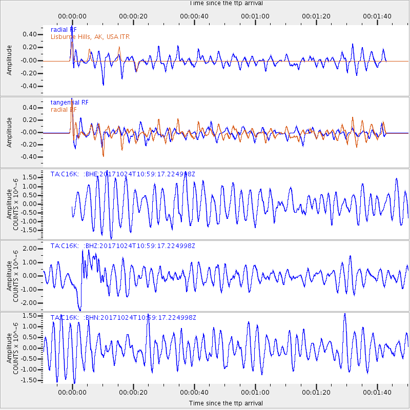
C16K Lisburne Hills, AK, USA - Earthquake Result Viewer
*The percent match for this event was below the threshold and hence no stack was calculated.
| Earthquake location: |
Banda Sea |
| Earthquake latitude/longitude: |
-7.2/123.0 |
| Earthquake time(UTC): |
2017/10/24 (297) 10:47:47 GMT |
| Earthquake Depth: |
549 km |
| Earthquake Magnitude: |
6.7 Mww |
| Earthquake Catalog/Contributor: |
NEIC PDE/us |
|
| Network: |
TA USArray Transportable Network (new EarthScope stations) |
| Station: |
C16K Lisburne Hills, AK, USA |
| Lat/Lon: |
68.27 N/165.34 W |
| Elevation: |
102 m |
|
| Distance: |
90.0 deg |
| Az: |
20.69 deg |
| Baz: |
250.306 deg |
| Ray Param: |
$rayparam |
*The percent match for this event was below the threshold and hence was not used in the summary stack. |
|
| Radial Match: |
60.785816 % |
| Radial Bump: |
346 |
| Transverse Match: |
60.584503 % |
| Transverse Bump: |
400 |
| SOD ConfigId: |
13570011 |
| Insert Time: |
2019-04-29 00:29:06.889 +0000 |
| GWidth: |
2.5 |
| Max Bumps: |
400 |
| Tol: |
0.001 |
|
Signal To Noise
| Channel | StoN | STA | LTA |
| TA:C16K: :BHZ:20171024T10:59:17.224998Z | 3.038394 | 1.2630122E-6 | 4.1568413E-7 |
| TA:C16K: :BHN:20171024T10:59:17.224998Z | 1.8639543 | 8.9887885E-7 | 4.8224297E-7 |
| TA:C16K: :BHE:20171024T10:59:17.224998Z | 0.84993196 | 7.985134E-7 | 9.395027E-7 |
| Arrivals |
| Ps | |
| PpPs | |
| PsPs/PpSs | |


