You are here: Home > Network List > CI - Caltech Regional Seismic Network Stations List
> Station SMM Simmler, CA, USA > Earthquake Result Viewer
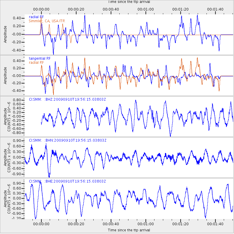
SMM Simmler, CA, USA - Earthquake Result Viewer
*The percent match for this event was below the threshold and hence no stack was calculated.
| Earthquake location: |
Easter Island Region |
| Earthquake latitude/longitude: |
-29.9/-111.8 |
| Earthquake time(UTC): |
2009/09/10 (253) 19:46:03 GMT |
| Earthquake Depth: |
10 km |
| Earthquake Magnitude: |
5.5 MW, 5.4 MB |
| Earthquake Catalog/Contributor: |
WHDF/NEIC |
|
| Network: |
CI Caltech Regional Seismic Network |
| Station: |
SMM Simmler, CA, USA |
| Lat/Lon: |
35.31 N/120.00 W |
| Elevation: |
599 m |
|
| Distance: |
65.3 deg |
| Az: |
352.652 deg |
| Baz: |
172.197 deg |
| Ray Param: |
$rayparam |
*The percent match for this event was below the threshold and hence was not used in the summary stack. |
|
| Radial Match: |
57.12474 % |
| Radial Bump: |
400 |
| Transverse Match: |
56.41259 % |
| Transverse Bump: |
337 |
| SOD ConfigId: |
2622 |
| Insert Time: |
2010-02-26 01:32:45.132 +0000 |
| GWidth: |
2.5 |
| Max Bumps: |
400 |
| Tol: |
0.001 |
|
Signal To Noise
| Channel | StoN | STA | LTA |
| CI:SMM: :BHN:20090910T19:56:15.03803Z | 2.3608303 | 4.6927443E-7 | 1.9877517E-7 |
| CI:SMM: :BHE:20090910T19:56:15.03803Z | 1.6485697 | 5.626565E-7 | 3.412998E-7 |
| CI:SMM: :BHZ:20090910T19:56:15.03803Z | 0.93270826 | 2.2906472E-7 | 2.4559097E-7 |
| Arrivals |
| Ps | |
| PpPs | |
| PsPs/PpSs | |


