You are here: Home > Network List > TA - USArray Transportable Network (new EarthScope stations) Stations List
> Station K13K Kusilvak Mountain, AK, USA > Earthquake Result Viewer
K13K Kusilvak Mountain, AK, USA - Earthquake Result Viewer

| Earthquake location: |
Banda Sea |
| Earthquake latitude/longitude: |
-7.2/123.0 |
| Earthquake time(UTC): |
2017/10/24 (297) 10:47:47 GMT |
| Earthquake Depth: |
549 km |
| Earthquake Magnitude: |
6.7 Mww |
| Earthquake Catalog/Contributor: |
NEIC PDE/us |
|
| Network: |
TA USArray Transportable Network (new EarthScope stations) |
| Station: |
K13K Kusilvak Mountain, AK, USA |
| Lat/Lon: |
61.93 N/164.66 W |
| Elevation: |
204 m |
|
| Distance: |
88.1 deg |
| Az: |
26.797 deg |
| Baz: |
251.031 deg |
| Ray Param: |
0.041688804 |
| Estimated Moho Depth: |
22.5 km |
| Estimated Crust Vp/Vs: |
2.10 |
| Assumed Crust Vp: |
6.1 km/s |
| Estimated Crust Vs: |
2.908 km/s |
| Estimated Crust Poisson's Ratio: |
0.35 |
|
| Radial Match: |
83.93458 % |
| Radial Bump: |
400 |
| Transverse Match: |
54.6548 % |
| Transverse Bump: |
400 |
| SOD ConfigId: |
13570011 |
| Insert Time: |
2019-04-29 00:29:48.505 +0000 |
| GWidth: |
2.5 |
| Max Bumps: |
400 |
| Tol: |
0.001 |
|
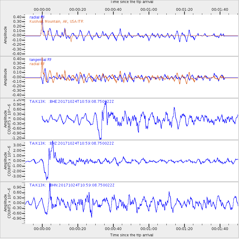
Signal To Noise
| Channel | StoN | STA | LTA |
| TA:K13K: :BHZ:20171024T10:59:08.750022Z | 18.684378 | 1.9094753E-6 | 1.0219635E-7 |
| TA:K13K: :BHN:20171024T10:59:08.750022Z | 2.1101892 | 4.665584E-7 | 2.2109788E-7 |
| TA:K13K: :BHE:20171024T10:59:08.750022Z | 4.176164 | 6.8090264E-7 | 1.63045E-7 |
| Arrivals |
| Ps | 4.1 SECOND |
| PpPs | 11 SECOND |
| PsPs/PpSs | 15 SECOND |


