You are here: Home > Network List > TA - USArray Transportable Network (new EarthScope stations) Stations List
> Station I13A Wildhorse Creek, Mackay, ID, USA > Earthquake Result Viewer
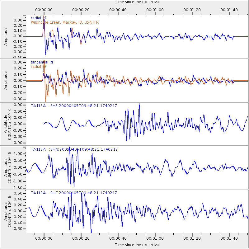
I13A Wildhorse Creek, Mackay, ID, USA - Earthquake Result Viewer
*The percent match for this event was below the threshold and hence no stack was calculated.
| Earthquake location: |
Kyushu, Japan |
| Earthquake latitude/longitude: |
32.0/131.4 |
| Earthquake time(UTC): |
2009/04/05 (095) 09:36:26 GMT |
| Earthquake Depth: |
26 km |
| Earthquake Magnitude: |
5.8 MB, 5.4 MS, 5.8 MW, 5.8 MW |
| Earthquake Catalog/Contributor: |
WHDF/NEIC |
|
| Network: |
TA USArray Transportable Network (new EarthScope stations) |
| Station: |
I13A Wildhorse Creek, Mackay, ID, USA |
| Lat/Lon: |
43.91 N/114.12 W |
| Elevation: |
2104 m |
|
| Distance: |
83.7 deg |
| Az: |
41.44 deg |
| Baz: |
308.919 deg |
| Ray Param: |
$rayparam |
*The percent match for this event was below the threshold and hence was not used in the summary stack. |
|
| Radial Match: |
72.235054 % |
| Radial Bump: |
400 |
| Transverse Match: |
49.12707 % |
| Transverse Bump: |
400 |
| SOD ConfigId: |
2658 |
| Insert Time: |
2010-03-06 05:27:01.600 +0000 |
| GWidth: |
2.5 |
| Max Bumps: |
400 |
| Tol: |
0.001 |
|
Signal To Noise
| Channel | StoN | STA | LTA |
| TA:I13A: :BHN:20090405T09:48:21.174021Z | 2.7456853 | 4.4363097E-7 | 1.6157385E-7 |
| TA:I13A: :BHE:20090405T09:48:21.174021Z | 1.6227196 | 1.3258172E-7 | 8.1703405E-8 |
| TA:I13A: :BHZ:20090405T09:48:21.174021Z | 0.7678335 | 1.12293414E-7 | 1.4624709E-7 |
| Arrivals |
| Ps | |
| PpPs | |
| PsPs/PpSs | |


