You are here: Home > Network List > UU - University of Utah Regional Network Stations List
> Station PSUT Pine Spring, UT, USA > Earthquake Result Viewer
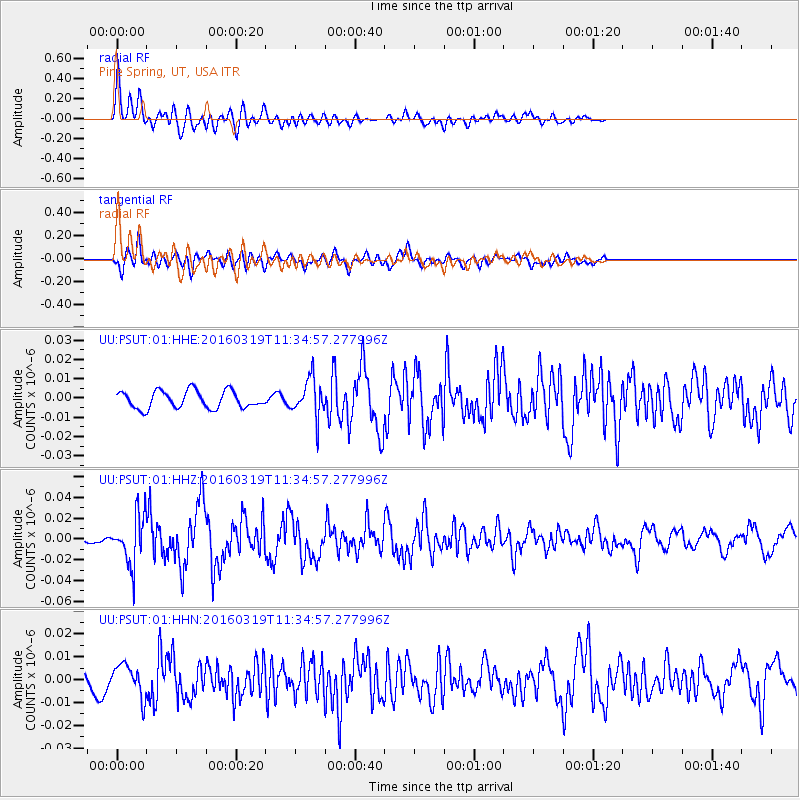
PSUT Pine Spring, UT, USA - Earthquake Result Viewer
*The percent match for this event was below the threshold and hence no stack was calculated.
| Earthquake location: |
Leeward Islands |
| Earthquake latitude/longitude: |
18.0/-60.7 |
| Earthquake time(UTC): |
2016/03/19 (079) 11:26:34 GMT |
| Earthquake Depth: |
32 km |
| Earthquake Magnitude: |
6.0 MWW, 5.9 MWB |
| Earthquake Catalog/Contributor: |
NEIC PDE/NEIC COMCAT |
|
| Network: |
UU University of Utah Regional Network |
| Station: |
PSUT Pine Spring, UT, USA |
| Lat/Lon: |
38.53 N/113.85 W |
| Elevation: |
1999 m |
|
| Distance: |
50.4 deg |
| Az: |
305.403 deg |
| Baz: |
98.462 deg |
| Ray Param: |
$rayparam |
*The percent match for this event was below the threshold and hence was not used in the summary stack. |
|
| Radial Match: |
75.97845 % |
| Radial Bump: |
400 |
| Transverse Match: |
55.975307 % |
| Transverse Bump: |
400 |
| SOD ConfigId: |
1464191 |
| Insert Time: |
2016-04-02 12:09:55.228 +0000 |
| GWidth: |
2.5 |
| Max Bumps: |
400 |
| Tol: |
0.001 |
|
Signal To Noise
| Channel | StoN | STA | LTA |
| UU:PSUT:01:HHZ:20160319T11:34:57.277996Z | 5.672077 | 2.359553E-8 | 4.1599453E-9 |
| UU:PSUT:01:HHN:20160319T11:34:57.277996Z | 1.5735818 | 7.125851E-9 | 4.5284274E-9 |
| UU:PSUT:01:HHE:20160319T11:34:57.277996Z | 2.2080617 | 9.888378E-9 | 4.4783066E-9 |
| Arrivals |
| Ps | |
| PpPs | |
| PsPs/PpSs | |


