You are here: Home > Network List > TA - USArray Transportable Network (new EarthScope stations) Stations List
> Station 218A Dragoon, AZ, USA > Earthquake Result Viewer
218A Dragoon, AZ, USA - Earthquake Result Viewer
| Earthquake location: |
Loyalty Islands |
| Earthquake latitude/longitude: |
-20.2/168.9 |
| Earthquake time(UTC): |
2008/04/09 (100) 11:13:17 GMT |
| Earthquake Depth: |
13 km |
| Earthquake Magnitude: |
5.6 MB, 6.3 MS, 6.4 MW, 6.3 MW |
| Earthquake Catalog/Contributor: |
WHDF/NEIC |
|
| Network: |
TA USArray Transportable Network (new EarthScope stations) |
| Station: |
218A Dragoon, AZ, USA |
| Lat/Lon: |
31.97 N/110.05 W |
| Elevation: |
1486 m |
|
| Distance: |
93.3 deg |
| Az: |
57.246 deg |
| Baz: |
248.369 deg |
| Ray Param: |
0.041292466 |
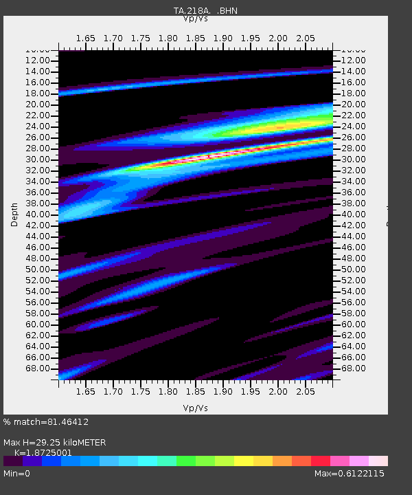
| Estimated Moho Depth: |
29.25 km |
| Estimated Crust Vp/Vs: |
1.87 |
| Assumed Crust Vp: |
6.264 km/s |
| Estimated Crust Vs: |
3.345 km/s |
| Estimated Crust Poisson's Ratio: |
0.30 |
|
| Radial Match: |
81.46412 % |
| Radial Bump: |
359 |
| Transverse Match: |
45.147655 % |
| Transverse Bump: |
400 |
| SOD ConfigId: |
2504 |
| Insert Time: |
2010-03-06 05:27:20.599 +0000 |
| GWidth: |
2.5 |
| Max Bumps: |
400 |
| Tol: |
0.001 |
|
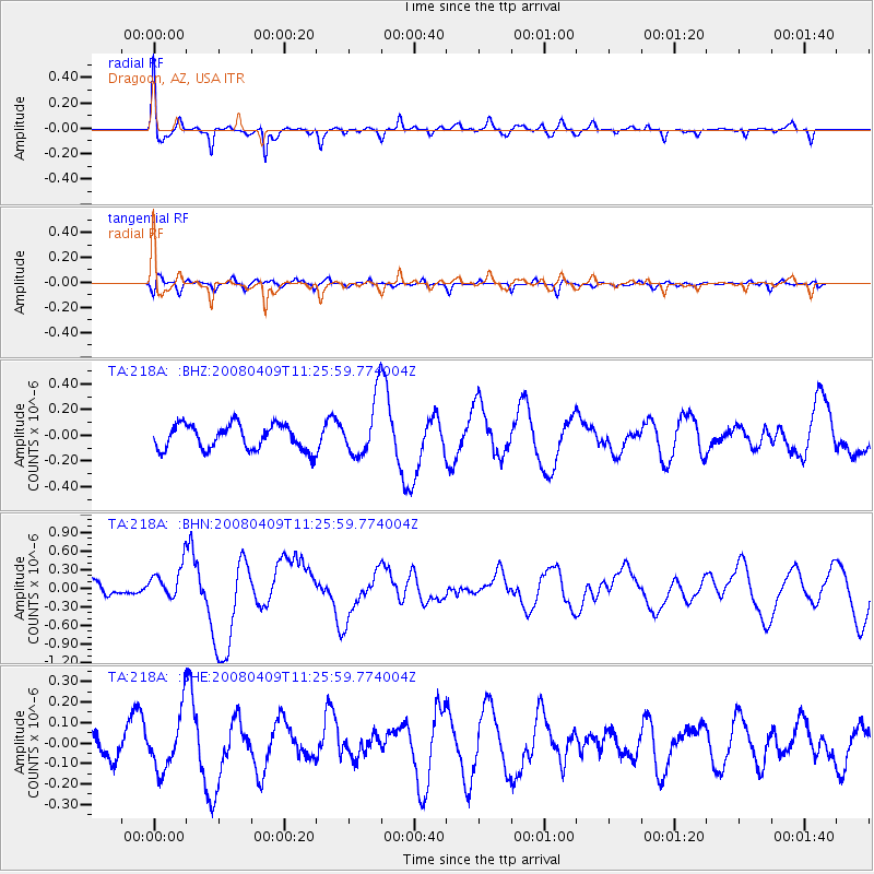
Signal To Noise
| Channel | StoN | STA | LTA |
| TA:218A: :BHN:20080409T11:25:59.774004Z | 1.6057848 | 2.719185E-7 | 1.6933683E-7 |
| TA:218A: :BHE:20080409T11:25:59.774004Z | 1.4578946 | 1.3839471E-7 | 9.49278E-8 |
| TA:218A: :BHZ:20080409T11:25:59.774004Z | 2.321475 | 2.2574858E-7 | 9.724359E-8 |
| Arrivals |
| Ps | 4.1 SECOND |
| PpPs | 13 SECOND |
| PsPs/PpSs | 17 SECOND |


