You are here: Home > Network List > TA - USArray Transportable Network (new EarthScope stations) Stations List
> Station 218A Dragoon, AZ, USA > Earthquake Result Viewer
218A Dragoon, AZ, USA - Earthquake Result Viewer
| Earthquake location: |
Easter Island Region |
| Earthquake latitude/longitude: |
-28.5/-112.8 |
| Earthquake time(UTC): |
2008/08/19 (232) 10:58:00 GMT |
| Earthquake Depth: |
9.0 km |
| Earthquake Magnitude: |
5.5 MB, 5.3 MS, 5.7 MW, 5.7 MW |
| Earthquake Catalog/Contributor: |
WHDF/NEIC |
|
| Network: |
TA USArray Transportable Network (new EarthScope stations) |
| Station: |
218A Dragoon, AZ, USA |
| Lat/Lon: |
31.97 N/110.05 W |
| Elevation: |
1486 m |
|
| Distance: |
60.2 deg |
| Az: |
2.737 deg |
| Baz: |
182.833 deg |
| Ray Param: |
0.061663307 |
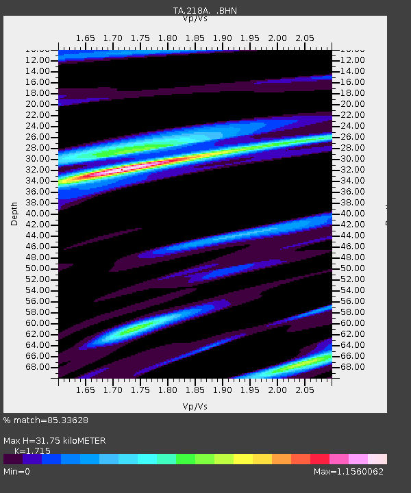
| Estimated Moho Depth: |
31.75 km |
| Estimated Crust Vp/Vs: |
1.72 |
| Assumed Crust Vp: |
6.264 km/s |
| Estimated Crust Vs: |
3.652 km/s |
| Estimated Crust Poisson's Ratio: |
0.24 |
|
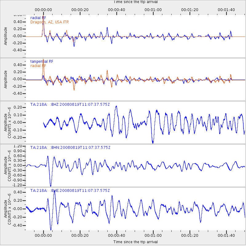
| Radial Match: |
85.33628 % |
| Radial Bump: |
369 |
| Transverse Match: |
62.894455 % |
| Transverse Bump: |
361 |
| SOD ConfigId: |
2504 |
| Insert Time: |
2010-03-06 05:27:55.723 +0000 |
| GWidth: |
2.5 |
| Max Bumps: |
400 |
| Tol: |
0.001 |
|
Signal To Noise
| Channel | StoN | STA | LTA |
| TA:218A: :BHN:20080819T11:07:37.575Z | 6.958203 | 5.3879904E-7 | 7.743365E-8 |
| TA:218A: :BHE:20080819T11:07:37.575Z | 3.9191387 | 2.1052908E-7 | 5.37182E-8 |
| TA:218A: :BHZ:20080819T11:07:37.575Z | 0.87512356 | 4.5254126E-8 | 5.1711698E-8 |
| Arrivals |
| Ps | 3.8 SECOND |
| PpPs | 13 SECOND |
| PsPs/PpSs | 17 SECOND |


