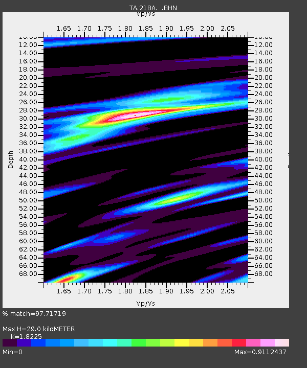
218A Dragoon, AZ, USA - Earthquake Result Viewer
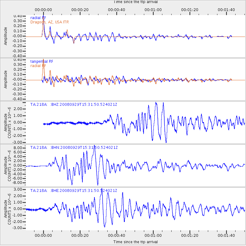
Earthquake location: Kermadec Islands, New Zealand
Earthquake latitude/longitude: -29.8/-177.7
Earthquake time(UTC): 2008/09/29 (273) 15:19:31 GMT
Earthquake Depth: 36 km
Earthquake Magnitude: 6.5 MB, 6.7 MS, 7.0 MW, 7.0 MW
Earthquake Catalog/Contributor: WHDF/NEIC
Network: TA USArray Transportable Network (new EarthScope stations)
Station: 218A Dragoon, AZ, USA
Lat/Lon: 31.97 N/110.05 W
Elevation: 1486 m
Distance: 88.8 deg
Az: 51.826 deg
Baz: 233.548 deg
Ray Param: 0.042269137
Estimated Moho Depth: 29.0 km
Estimated Crust Vp/Vs: 1.82
Assumed Crust Vp: 6.264 km/s
Estimated Crust Vs: 3.437 km/s
Estimated Crust Poisson's Ratio: 0.28
Radial Match: 97.71719 %
Radial Bump: 336
Transverse Match: 94.125824 %
Transverse Bump: 400
SOD ConfigId: 2560
Insert Time: 2010-03-06 05:28:19.881 +0000
GWidth: 2.5
Max Bumps: 400
Tol: 0.001

Signal To Noise

ChannelStoNSTALTA
TA:218A: :BHN:20080929T15:31:50.524021Z5.6066134.664196E-78.319097E-8
TA:218A: :BHE:20080929T15:31:50.524021Z1.89247241.3152679E-76.9499976E-8
TA:218A: :BHZ:20080929T15:31:50.524021Z1.76431731.6911406E-79.585241E-8
Arrivals
Ps3.9 SECOND
PpPs13 SECOND
PsPs/PpSs17 SECOND