You are here: Home > Network List > TA - USArray Transportable Network (new EarthScope stations) Stations List
> Station 218A Dragoon, AZ, USA > Earthquake Result Viewer
218A Dragoon, AZ, USA - Earthquake Result Viewer
| Earthquake location: |
Svalbard Region |
| Earthquake latitude/longitude: |
77.1/18.6 |
| Earthquake time(UTC): |
2008/02/21 (052) 02:46:17 GMT |
| Earthquake Depth: |
10 km |
| Earthquake Magnitude: |
5.7 MB, 5.9 MS, 6.1 MW, 6.0 MW |
| Earthquake Catalog/Contributor: |
WHDF/NEIC |
|
| Network: |
TA USArray Transportable Network (new EarthScope stations) |
| Station: |
218A Dragoon, AZ, USA |
| Lat/Lon: |
31.97 N/110.05 W |
| Elevation: |
1486 m |
|
| Distance: |
66.8 deg |
| Az: |
313.739 deg |
| Baz: |
11.028 deg |
| Ray Param: |
0.057382163 |
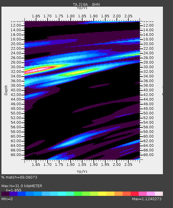
| Estimated Moho Depth: |
31.0 km |
| Estimated Crust Vp/Vs: |
1.65 |
| Assumed Crust Vp: |
6.264 km/s |
| Estimated Crust Vs: |
3.785 km/s |
| Estimated Crust Poisson's Ratio: |
0.21 |
|
| Radial Match: |
88.06073 % |
| Radial Bump: |
400 |
| Transverse Match: |
61.075268 % |
| Transverse Bump: |
400 |
| SOD ConfigId: |
2564 |
| Insert Time: |
2010-03-06 05:28:29.622 +0000 |
| GWidth: |
2.5 |
| Max Bumps: |
400 |
| Tol: |
0.001 |
|
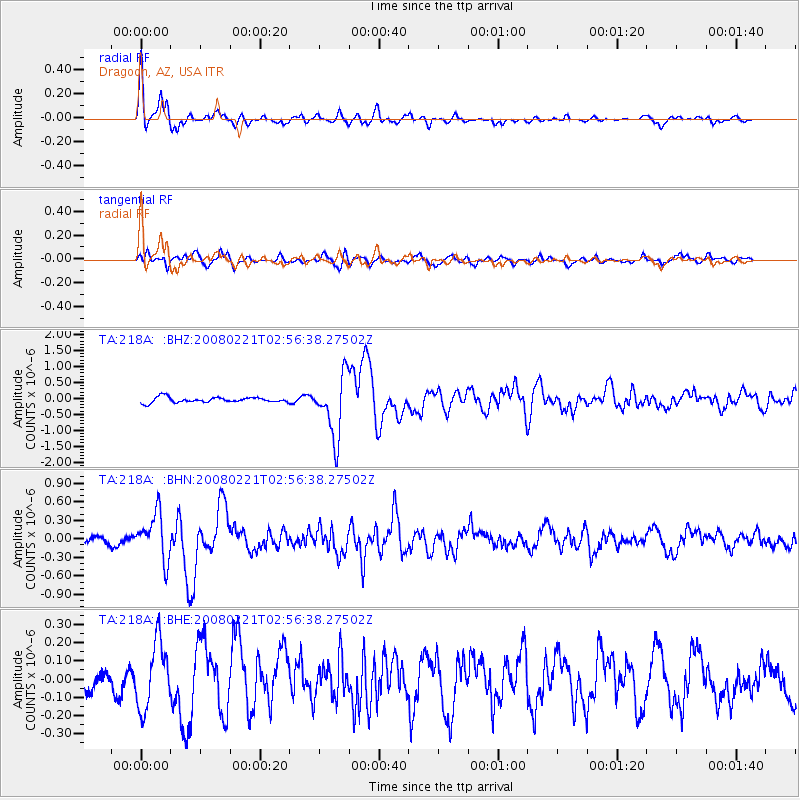
Signal To Noise
| Channel | StoN | STA | LTA |
| TA:218A: :BHN:20080221T02:56:38.27502Z | 3.776229 | 3.7043773E-7 | 9.809727E-8 |
| TA:218A: :BHE:20080221T02:56:38.27502Z | 2.2286415 | 1.8041153E-7 | 8.095135E-8 |
| TA:218A: :BHZ:20080221T02:56:38.27502Z | 11.591232 | 9.551579E-7 | 8.240348E-8 |
| Arrivals |
| Ps | 3.4 SECOND |
| PpPs | 13 SECOND |
| PsPs/PpSs | 16 SECOND |


