You are here: Home > Network List > TA - USArray Transportable Network (new EarthScope stations) Stations List
> Station 218A Dragoon, AZ, USA > Earthquake Result Viewer
218A Dragoon, AZ, USA - Earthquake Result Viewer
| Earthquake location: |
Kermadec Islands, New Zealand |
| Earthquake latitude/longitude: |
-30.0/-177.9 |
| Earthquake time(UTC): |
2007/11/20 (324) 15:28:28 GMT |
| Earthquake Depth: |
59 km |
| Earthquake Magnitude: |
6.0 MB, 5.9 MW, 5.8 MW |
| Earthquake Catalog/Contributor: |
WHDF/NEIC |
|
| Network: |
TA USArray Transportable Network (new EarthScope stations) |
| Station: |
218A Dragoon, AZ, USA |
| Lat/Lon: |
31.97 N/110.05 W |
| Elevation: |
1486 m |
|
| Distance: |
89.1 deg |
| Az: |
51.946 deg |
| Baz: |
233.462 deg |
| Ray Param: |
0.041968685 |
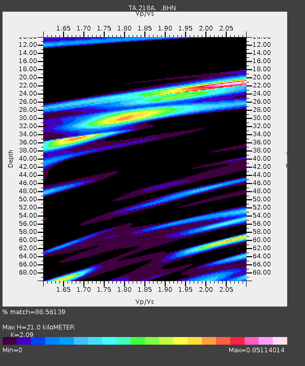
| Estimated Moho Depth: |
21.0 km |
| Estimated Crust Vp/Vs: |
2.09 |
| Assumed Crust Vp: |
6.264 km/s |
| Estimated Crust Vs: |
2.997 km/s |
| Estimated Crust Poisson's Ratio: |
0.35 |
|
| Radial Match: |
88.56139 % |
| Radial Bump: |
362 |
| Transverse Match: |
82.556526 % |
| Transverse Bump: |
400 |
| SOD ConfigId: |
2564 |
| Insert Time: |
2010-03-06 05:28:50.357 +0000 |
| GWidth: |
2.5 |
| Max Bumps: |
400 |
| Tol: |
0.001 |
|
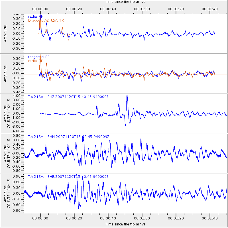
Signal To Noise
| Channel | StoN | STA | LTA |
| TA:218A: :BHN:20071120T15:40:45.949009Z | 1.2565459 | 1.1458522E-7 | 9.1190635E-8 |
| TA:218A: :BHE:20071120T15:40:45.949009Z | 1.1372899 | 1.6011649E-7 | 1.4078776E-7 |
| TA:218A: :BHZ:20071120T15:40:45.949009Z | 4.3405213 | 6.049442E-7 | 1.3937132E-7 |
| Arrivals |
| Ps | 3.7 SECOND |
| PpPs | 10 SECOND |
| PsPs/PpSs | 14 SECOND |


