You are here: Home > Network List > TA - USArray Transportable Network (new EarthScope stations) Stations List
> Station 218A Dragoon, AZ, USA > Earthquake Result Viewer
218A Dragoon, AZ, USA - Earthquake Result Viewer
| Earthquake location: |
Near Coast Of Northern Chile |
| Earthquake latitude/longitude: |
-22.9/-70.4 |
| Earthquake time(UTC): |
2007/11/15 (319) 15:03:08 GMT |
| Earthquake Depth: |
27 km |
| Earthquake Magnitude: |
5.8 MB, 6.1 MW, 5.5 ML |
| Earthquake Catalog/Contributor: |
WHDF/NEIC |
|
| Network: |
TA USArray Transportable Network (new EarthScope stations) |
| Station: |
218A Dragoon, AZ, USA |
| Lat/Lon: |
31.97 N/110.05 W |
| Elevation: |
1486 m |
|
| Distance: |
66.4 deg |
| Az: |
323.731 deg |
| Baz: |
140.058 deg |
| Ray Param: |
0.057590656 |
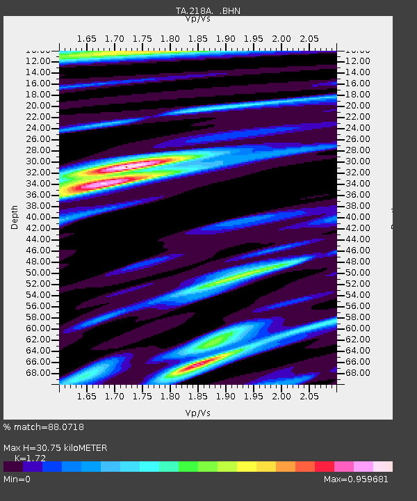
| Estimated Moho Depth: |
30.75 km |
| Estimated Crust Vp/Vs: |
1.72 |
| Assumed Crust Vp: |
6.264 km/s |
| Estimated Crust Vs: |
3.642 km/s |
| Estimated Crust Poisson's Ratio: |
0.24 |
|
| Radial Match: |
88.0718 % |
| Radial Bump: |
376 |
| Transverse Match: |
65.46071 % |
| Transverse Bump: |
400 |
| SOD ConfigId: |
2564 |
| Insert Time: |
2010-03-06 05:28:51.749 +0000 |
| GWidth: |
2.5 |
| Max Bumps: |
400 |
| Tol: |
0.001 |
|
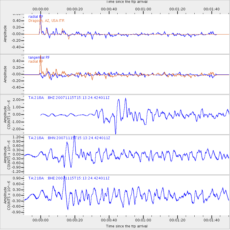
Signal To Noise
| Channel | StoN | STA | LTA |
| TA:218A: :BHN:20071115T15:13:24.424011Z | 1.813923 | 1.6502717E-7 | 9.097805E-8 |
| TA:218A: :BHE:20071115T15:13:24.424011Z | 2.1413736 | 1.9634642E-7 | 9.169181E-8 |
| TA:218A: :BHZ:20071115T15:13:24.424011Z | 2.965778 | 2.9606215E-7 | 9.982613E-8 |
| Arrivals |
| Ps | 3.7 SECOND |
| PpPs | 13 SECOND |
| PsPs/PpSs | 17 SECOND |


