You are here: Home > Network List > TA - USArray Transportable Network (new EarthScope stations) Stations List
> Station 218A Dragoon, AZ, USA > Earthquake Result Viewer
218A Dragoon, AZ, USA - Earthquake Result Viewer
| Earthquake location: |
East Of Kuril Islands |
| Earthquake latitude/longitude: |
46.0/154.2 |
| Earthquake time(UTC): |
2007/10/25 (298) 13:50:02 GMT |
| Earthquake Depth: |
10 km |
| Earthquake Magnitude: |
6.0 MB, 5.7 MS, 6.1 MW, 5.9 MW |
| Earthquake Catalog/Contributor: |
WHDF/NEIC |
|
| Network: |
TA USArray Transportable Network (new EarthScope stations) |
| Station: |
218A Dragoon, AZ, USA |
| Lat/Lon: |
31.97 N/110.05 W |
| Elevation: |
1486 m |
|
| Distance: |
71.4 deg |
| Az: |
63.151 deg |
| Baz: |
312.975 deg |
| Ray Param: |
0.054347776 |
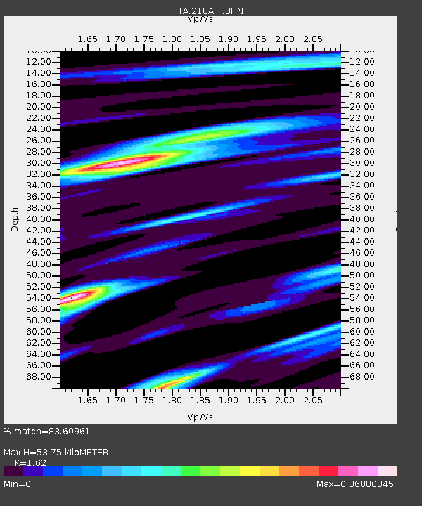
| Estimated Moho Depth: |
53.75 km |
| Estimated Crust Vp/Vs: |
1.62 |
| Assumed Crust Vp: |
6.264 km/s |
| Estimated Crust Vs: |
3.866 km/s |
| Estimated Crust Poisson's Ratio: |
0.19 |
|
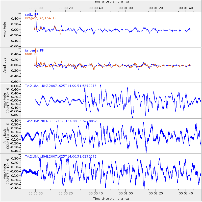
| Radial Match: |
83.60961 % |
| Radial Bump: |
302 |
| Transverse Match: |
69.82183 % |
| Transverse Bump: |
329 |
| SOD ConfigId: |
2564 |
| Insert Time: |
2010-03-06 05:28:58.807 +0000 |
| GWidth: |
2.5 |
| Max Bumps: |
400 |
| Tol: |
0.001 |
|
Signal To Noise
| Channel | StoN | STA | LTA |
| TA:218A: :BHN:20071025T14:00:51.625005Z | 1.9926007 | 1.1921607E-7 | 5.982938E-8 |
| TA:218A: :BHE:20071025T14:00:51.625005Z | 2.8686435 | 1.3795314E-7 | 4.8090026E-8 |
| TA:218A: :BHZ:20071025T14:00:51.625005Z | 2.3939633 | 3.0848852E-7 | 1.2886102E-7 |
| Arrivals |
| Ps | 5.5 SECOND |
| PpPs | 22 SECOND |
| PsPs/PpSs | 27 SECOND |


