You are here: Home > Network List > CI - Caltech Regional Seismic Network Stations List
> Station SMM Simmler, CA, USA > Earthquake Result Viewer
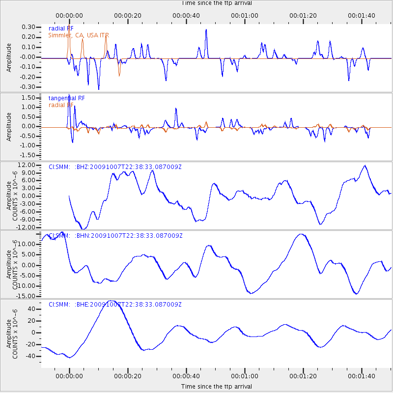
SMM Simmler, CA, USA - Earthquake Result Viewer
*The percent match for this event was below the threshold and hence no stack was calculated.
| Earthquake location: |
Santa Cruz Islands |
| Earthquake latitude/longitude: |
-12.1/166.6 |
| Earthquake time(UTC): |
2009/10/07 (280) 22:26:38 GMT |
| Earthquake Depth: |
35 km |
| Earthquake Magnitude: |
5.6 MB |
| Earthquake Catalog/Contributor: |
WHDF/NEIC |
|
| Network: |
CI Caltech Regional Seismic Network |
| Station: |
SMM Simmler, CA, USA |
| Lat/Lon: |
35.31 N/120.00 W |
| Elevation: |
599 m |
|
| Distance: |
83.7 deg |
| Az: |
52.027 deg |
| Baz: |
250.523 deg |
| Ray Param: |
$rayparam |
*The percent match for this event was below the threshold and hence was not used in the summary stack. |
|
| Radial Match: |
78.88726 % |
| Radial Bump: |
216 |
| Transverse Match: |
67.28931 % |
| Transverse Bump: |
279 |
| SOD ConfigId: |
2622 |
| Insert Time: |
2010-02-26 01:32:58.668 +0000 |
| GWidth: |
2.5 |
| Max Bumps: |
400 |
| Tol: |
0.001 |
|
Signal To Noise
| Channel | StoN | STA | LTA |
| CI:SMM: :BHN:20091007T22:38:33.087009Z | 0.41965395 | 4.288563E-6 | 1.0219284E-5 |
| CI:SMM: :BHE:20091007T22:38:33.087009Z | 1.6010547 | 3.7263995E-5 | 2.3274653E-5 |
| CI:SMM: :BHZ:20091007T22:38:33.087009Z | 0.45878693 | 3.598591E-6 | 7.843709E-6 |
| Arrivals |
| Ps | |
| PpPs | |
| PsPs/PpSs | |


