You are here: Home > Network List > TA - USArray Transportable Network (new EarthScope stations) Stations List
> Station MDND Maddock, ND, USA > Earthquake Result Viewer
MDND Maddock, ND, USA - Earthquake Result Viewer
*The percent match for this event was below the threshold and hence no stack was calculated.
| Earthquake location: |
North Of Franz Josef Land |
| Earthquake latitude/longitude: |
86.9/54.5 |
| Earthquake time(UTC): |
2017/10/28 (301) 16:13:54 GMT |
| Earthquake Depth: |
10 km |
| Earthquake Magnitude: |
5.8 Mww |
| Earthquake Catalog/Contributor: |
NEIC PDE/us |
|
| Network: |
TA USArray Transportable Network (new EarthScope stations) |
| Station: |
MDND Maddock, ND, USA |
| Lat/Lon: |
47.85 N/99.60 W |
| Elevation: |
479 m |
|
| Distance: |
45.2 deg |
| Az: |
335.491 deg |
| Baz: |
1.928 deg |
| Ray Param: |
$rayparam |
*The percent match for this event was below the threshold and hence was not used in the summary stack. |
|
| Radial Match: |
50.330982 % |
| Radial Bump: |
285 |
| Transverse Match: |
45.266327 % |
| Transverse Bump: |
284 |
| SOD ConfigId: |
13570011 |
| Insert Time: |
2019-04-29 00:41:56.265 +0000 |
| GWidth: |
2.5 |
| Max Bumps: |
400 |
| Tol: |
0.001 |
|
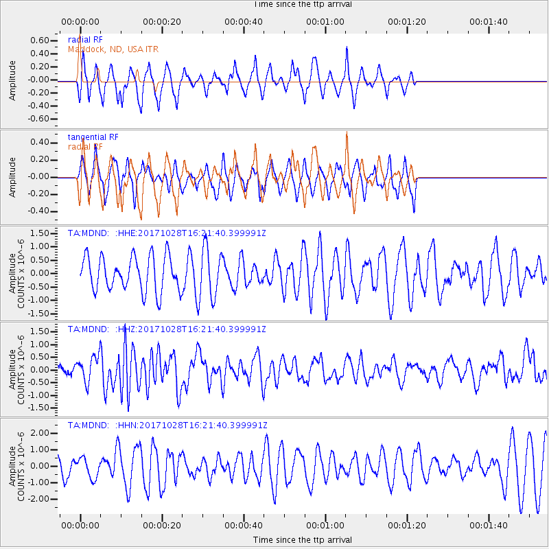
Signal To Noise
| Channel | StoN | STA | LTA |
| TA:MDND: :HHZ:20171028T16:21:40.399991Z | 2.2964578 | 5.0704625E-7 | 2.2079493E-7 |
| TA:MDND: :HHN:20171028T16:21:40.399991Z | 1.0657374 | 6.084636E-7 | 5.7093206E-7 |
| TA:MDND: :HHE:20171028T16:21:40.399991Z | 1.4774455 | 9.42371E-7 | 6.378381E-7 |
| Arrivals |
| Ps | |
| PpPs | |
| PsPs/PpSs | |


