You are here: Home > Network List > TA - USArray Transportable Network (new EarthScope stations) Stations List
> Station TPFO Pinon Flats, CA, USA > Earthquake Result Viewer
TPFO Pinon Flats, CA, USA - Earthquake Result Viewer
*The percent match for this event was below the threshold and hence no stack was calculated.
| Earthquake location: |
North Of Franz Josef Land |
| Earthquake latitude/longitude: |
86.9/54.5 |
| Earthquake time(UTC): |
2017/10/28 (301) 16:13:54 GMT |
| Earthquake Depth: |
10 km |
| Earthquake Magnitude: |
5.8 Mww |
| Earthquake Catalog/Contributor: |
NEIC PDE/us |
|
| Network: |
TA USArray Transportable Network (new EarthScope stations) |
| Station: |
TPFO Pinon Flats, CA, USA |
| Lat/Lon: |
33.61 N/116.45 W |
| Elevation: |
1275 m |
|
| Distance: |
59.7 deg |
| Az: |
351.251 deg |
| Baz: |
0.57 deg |
| Ray Param: |
$rayparam |
*The percent match for this event was below the threshold and hence was not used in the summary stack. |
|
| Radial Match: |
57.297466 % |
| Radial Bump: |
400 |
| Transverse Match: |
50.777298 % |
| Transverse Bump: |
337 |
| SOD ConfigId: |
13570011 |
| Insert Time: |
2019-04-29 00:42:16.025 +0000 |
| GWidth: |
2.5 |
| Max Bumps: |
400 |
| Tol: |
0.001 |
|
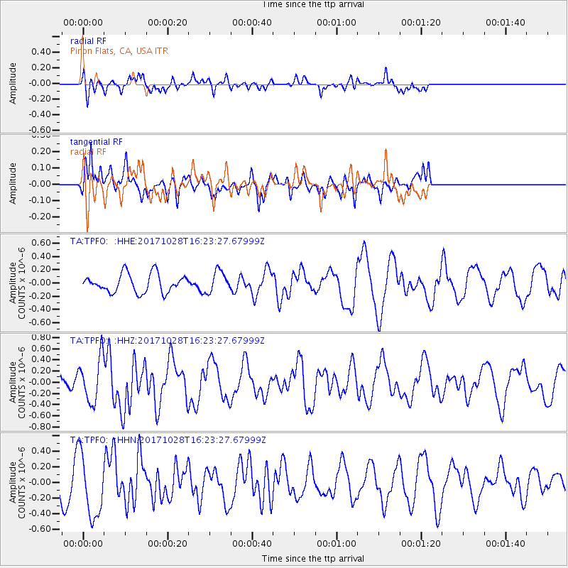
Signal To Noise
| Channel | StoN | STA | LTA |
| TA:TPFO: :HHZ:20171028T16:23:27.67999Z | 3.1671972 | 4.064261E-7 | 1.2832358E-7 |
| TA:TPFO: :HHN:20171028T16:23:27.67999Z | 2.785278 | 4.0070867E-7 | 1.4386666E-7 |
| TA:TPFO: :HHE:20171028T16:23:27.67999Z | 1.1696043 | 1.6178949E-7 | 1.3832839E-7 |
| Arrivals |
| Ps | |
| PpPs | |
| PsPs/PpSs | |


