You are here: Home > Network List > TA - USArray Transportable Network (new EarthScope stations) Stations List
> Station TUL3 Leonard, OK, USA > Earthquake Result Viewer
TUL3 Leonard, OK, USA - Earthquake Result Viewer
*The percent match for this event was below the threshold and hence no stack was calculated.
| Earthquake location: |
North Of Franz Josef Land |
| Earthquake latitude/longitude: |
86.9/54.5 |
| Earthquake time(UTC): |
2017/10/28 (301) 16:13:54 GMT |
| Earthquake Depth: |
10 km |
| Earthquake Magnitude: |
5.8 Mww |
| Earthquake Catalog/Contributor: |
NEIC PDE/us |
|
| Network: |
TA USArray Transportable Network (new EarthScope stations) |
| Station: |
TUL3 Leonard, OK, USA |
| Lat/Lon: |
35.91 N/95.79 W |
| Elevation: |
265 m |
|
| Distance: |
57.0 deg |
| Az: |
331.331 deg |
| Baz: |
1.85 deg |
| Ray Param: |
$rayparam |
*The percent match for this event was below the threshold and hence was not used in the summary stack. |
|
| Radial Match: |
69.69646 % |
| Radial Bump: |
358 |
| Transverse Match: |
49.05037 % |
| Transverse Bump: |
400 |
| SOD ConfigId: |
13570011 |
| Insert Time: |
2019-04-29 00:42:16.109 +0000 |
| GWidth: |
2.5 |
| Max Bumps: |
400 |
| Tol: |
0.001 |
|
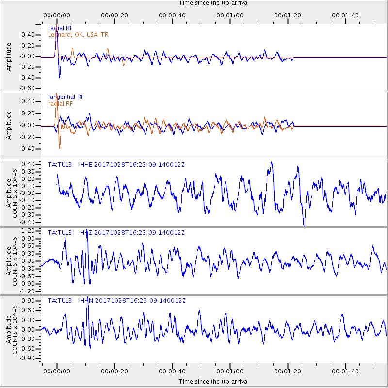
Signal To Noise
| Channel | StoN | STA | LTA |
| TA:TUL3: :HHZ:20171028T16:23:09.140012Z | 2.6296265 | 3.394974E-7 | 1.2910479E-7 |
| TA:TUL3: :HHN:20171028T16:23:09.140012Z | 1.6184014 | 2.3083366E-7 | 1.4263065E-7 |
| TA:TUL3: :HHE:20171028T16:23:09.140012Z | 0.92115796 | 9.74709E-8 | 1.0581345E-7 |
| Arrivals |
| Ps | |
| PpPs | |
| PsPs/PpSs | |


