You are here: Home > Network List > TA - USArray Transportable Network (new EarthScope stations) Stations List
> Station 218A Dragoon, AZ, USA > Earthquake Result Viewer
218A Dragoon, AZ, USA - Earthquake Result Viewer
| Earthquake location: |
Solomon Islands |
| Earthquake latitude/longitude: |
-8.5/157.0 |
| Earthquake time(UTC): |
2007/04/01 (091) 20:39:56 GMT |
| Earthquake Depth: |
10 km |
| Earthquake Magnitude: |
6.8 MB, 7.9 MS, 8.1 MW, 7.7 ME |
| Earthquake Catalog/Contributor: |
WHDF/NEIC |
|
| Network: |
TA USArray Transportable Network (new EarthScope stations) |
| Station: |
218A Dragoon, AZ, USA |
| Lat/Lon: |
31.97 N/110.05 W |
| Elevation: |
1486 m |
|
| Distance: |
96.9 deg |
| Az: |
58.752 deg |
| Baz: |
264.349 deg |
| Ray Param: |
0.040384162 |
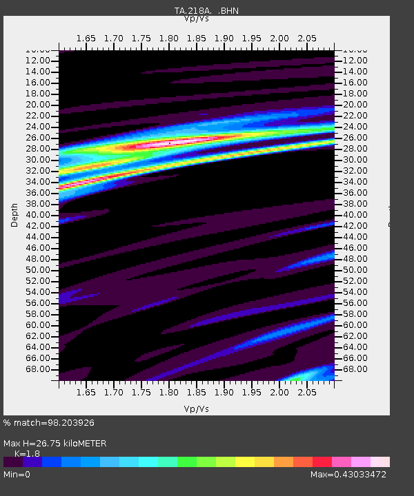
| Estimated Moho Depth: |
26.75 km |
| Estimated Crust Vp/Vs: |
1.80 |
| Assumed Crust Vp: |
6.264 km/s |
| Estimated Crust Vs: |
3.48 km/s |
| Estimated Crust Poisson's Ratio: |
0.28 |
|
| Radial Match: |
98.203926 % |
| Radial Bump: |
336 |
| Transverse Match: |
91.72324 % |
| Transverse Bump: |
400 |
| SOD ConfigId: |
2564 |
| Insert Time: |
2010-03-06 05:29:56.487 +0000 |
| GWidth: |
2.5 |
| Max Bumps: |
400 |
| Tol: |
0.001 |
|
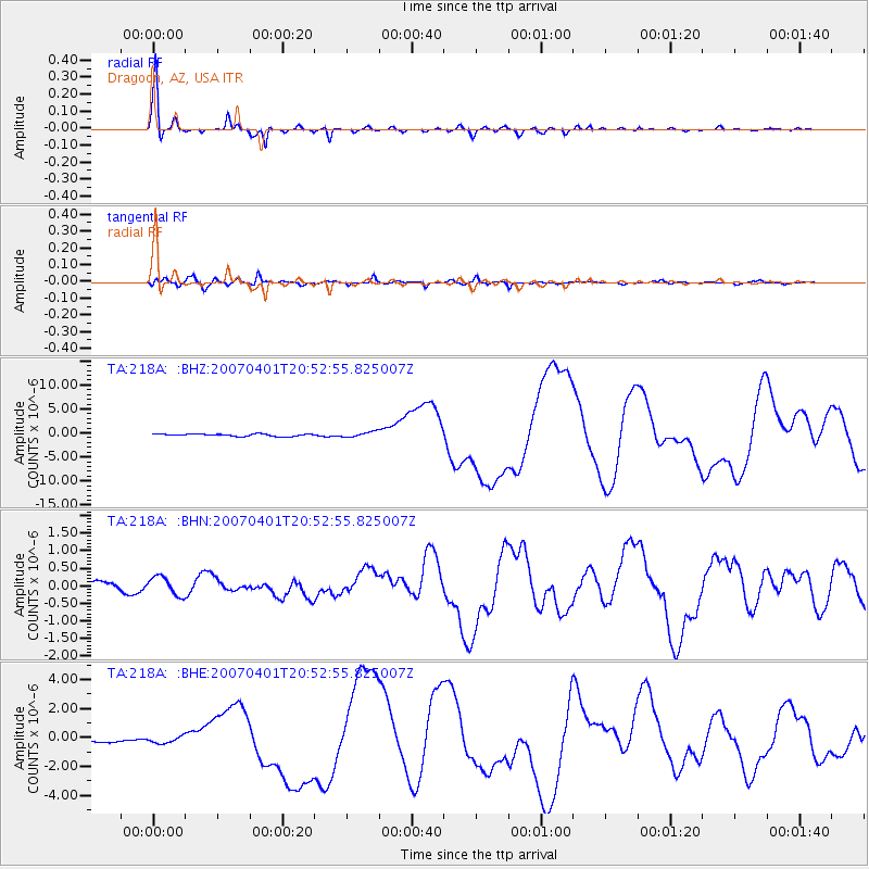
Signal To Noise
| Channel | StoN | STA | LTA |
| TA:218A: :BHN:20070401T20:52:55.825007Z | 1.7512909 | 2.742536E-7 | 1.5660082E-7 |
| TA:218A: :BHE:20070401T20:52:55.825007Z | 1.5411577 | 2.1348647E-7 | 1.3852345E-7 |
| TA:218A: :BHZ:20070401T20:52:55.825007Z | 2.2787957 | 5.523499E-7 | 2.4238673E-7 |
| Arrivals |
| Ps | 3.5 SECOND |
| PpPs | 12 SECOND |
| PsPs/PpSs | 15 SECOND |


