You are here: Home > Network List > AZ - ANZA Regional Network Stations List
> Station SMER AZ.SMER > Earthquake Result Viewer
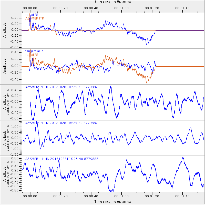
SMER AZ.SMER - Earthquake Result Viewer
*The percent match for this event was below the threshold and hence no stack was calculated.
| Earthquake location: |
North Of Franz Josef Land |
| Earthquake latitude/longitude: |
86.9/52.8 |
| Earthquake time(UTC): |
2017/10/28 (301) 16:16:06 GMT |
| Earthquake Depth: |
10 km |
| Earthquake Magnitude: |
5.8 Mww |
| Earthquake Catalog/Contributor: |
NEIC PDE/us |
|
| Network: |
AZ ANZA Regional Network |
| Station: |
SMER AZ.SMER |
| Lat/Lon: |
33.46 N/117.17 W |
| Elevation: |
355 m |
|
| Distance: |
59.8 deg |
| Az: |
350.35 deg |
| Baz: |
0.627 deg |
| Ray Param: |
$rayparam |
*The percent match for this event was below the threshold and hence was not used in the summary stack. |
|
| Radial Match: |
44.152557 % |
| Radial Bump: |
400 |
| Transverse Match: |
65.87207 % |
| Transverse Bump: |
400 |
| SOD ConfigId: |
13570011 |
| Insert Time: |
2019-04-29 00:45:08.940 +0000 |
| GWidth: |
2.5 |
| Max Bumps: |
400 |
| Tol: |
0.001 |
|
Signal To Noise
| Channel | StoN | STA | LTA |
| AZ:SMER: :HHZ:20171028T16:25:40.877988Z | 1.9816018 | 6.8843394E-7 | 3.4741285E-7 |
| AZ:SMER: :HHN:20171028T16:25:40.877988Z | 1.1462837 | 4.2132302E-7 | 3.675556E-7 |
| AZ:SMER: :HHE:20171028T16:25:40.877988Z | 0.8545056 | 2.5156638E-7 | 2.943999E-7 |
| Arrivals |
| Ps | |
| PpPs | |
| PsPs/PpSs | |


