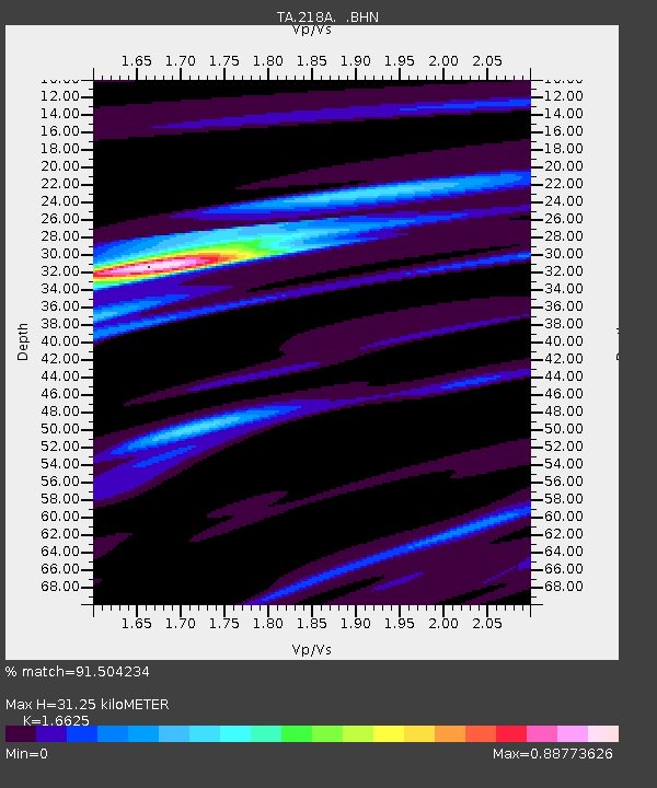
218A Dragoon, AZ, USA - Earthquake Result Viewer
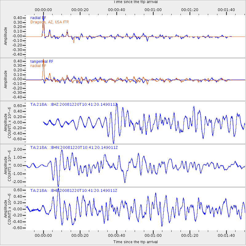
Earthquake location: Off East Coast Of Honshu, Japan
Earthquake latitude/longitude: 36.5/142.4
Earthquake time(UTC): 2008/12/20 (355) 10:29:23 GMT
Earthquake Depth: 19 km
Earthquake Magnitude: 6.0 MB, 6.3 MS, 6.3 MW, 6.3 MW
Earthquake Catalog/Contributor: WHDF/NEIC
Network: TA USArray Transportable Network (new EarthScope stations)
Station: 218A Dragoon, AZ, USA
Lat/Lon: 31.97 N/110.05 W
Elevation: 1486 m
Distance: 83.9 deg
Az: 54.591 deg
Baz: 309.438 deg
Ray Param: 0.045842696
Estimated Moho Depth: 31.25 km
Estimated Crust Vp/Vs: 1.66
Assumed Crust Vp: 6.264 km/s
Estimated Crust Vs: 3.768 km/s
Estimated Crust Poisson's Ratio: 0.22
Radial Match: 91.504234 %
Radial Bump: 253
Transverse Match: 69.9005 %
Transverse Bump: 400
SOD ConfigId: 2658
Insert Time: 2010-03-06 05:30:06.017 +0000
GWidth: 2.5
Max Bumps: 400
Tol: 0.001

Signal To Noise

ChannelStoNSTALTA
TA:218A: :BHN:20081220T10:41:20.149011Z2.97706873.101363E-71.0417506E-7
TA:218A: :BHE:20081220T10:41:20.149011Z1.44300351.0968421E-77.601105E-8
TA:218A: :BHZ:20081220T10:41:20.149011Z1.22019341.2140227E-79.949429E-8
Arrivals
Ps3.4 SECOND
PpPs13 SECOND
PsPs/PpSs16 SECOND