You are here: Home > Network List > CI - Caltech Regional Seismic Network Stations List
> Station SMM Simmler, CA, USA > Earthquake Result Viewer
SMM Simmler, CA, USA - Earthquake Result Viewer
*The percent match for this event was below the threshold and hence no stack was calculated.
| Earthquake location: |
Fox Islands, Aleutian Islands |
| Earthquake latitude/longitude: |
52.8/-167.0 |
| Earthquake time(UTC): |
2009/10/13 (286) 05:37:23 GMT |
| Earthquake Depth: |
24 km |
| Earthquake Magnitude: |
6.0 MB, 6.1 MS, 6.5 MW, 6.5 MW |
| Earthquake Catalog/Contributor: |
WHDF/NEIC |
|
| Network: |
CI Caltech Regional Seismic Network |
| Station: |
SMM Simmler, CA, USA |
| Lat/Lon: |
35.31 N/120.00 W |
| Elevation: |
599 m |
|
| Distance: |
37.3 deg |
| Az: |
98.848 deg |
| Baz: |
312.746 deg |
| Ray Param: |
$rayparam |
*The percent match for this event was below the threshold and hence was not used in the summary stack. |
|
| Radial Match: |
87.42598 % |
| Radial Bump: |
400 |
| Transverse Match: |
87.92607 % |
| Transverse Bump: |
400 |
| SOD ConfigId: |
2622 |
| Insert Time: |
2010-02-26 01:33:03.630 +0000 |
| GWidth: |
2.5 |
| Max Bumps: |
400 |
| Tol: |
0.001 |
|
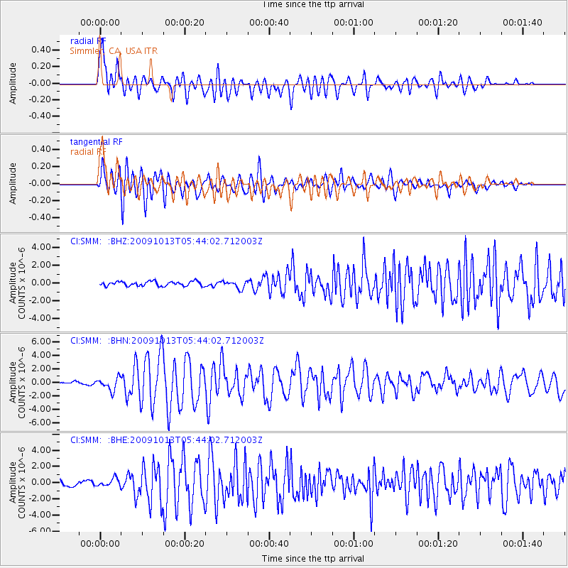
Signal To Noise
| Channel | StoN | STA | LTA |
| CI:SMM: :BHN:20091013T05:44:02.712003Z | 6.6757765 | 9.458866E-7 | 1.4168937E-7 |
| CI:SMM: :BHE:20091013T05:44:02.712003Z | 1.45749 | 5.00741E-7 | 3.4356393E-7 |
| CI:SMM: :BHZ:20091013T05:44:02.712003Z | 1.7460915 | 4.4048625E-7 | 2.5226984E-7 |
| Arrivals |
| Ps | |
| PpPs | |
| PsPs/PpSs | |


