You are here: Home > Network List > TA - USArray Transportable Network (new EarthScope stations) Stations List
> Station K15K Wolf Creek Mountain, AK, USA > Earthquake Result Viewer
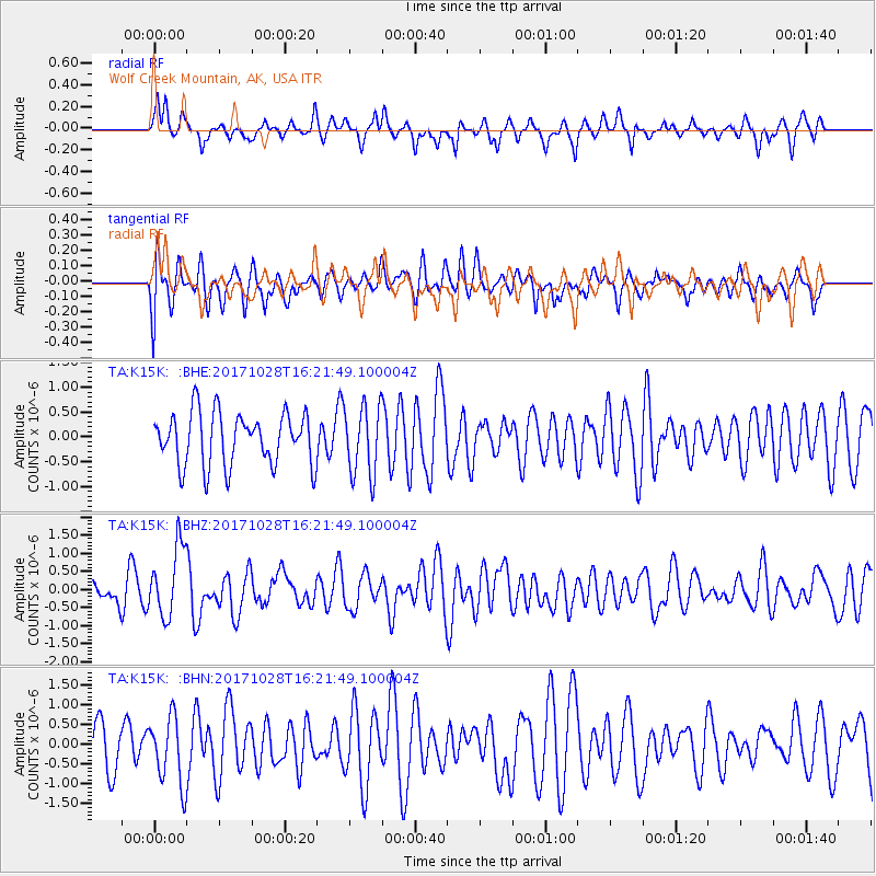
K15K Wolf Creek Mountain, AK, USA - Earthquake Result Viewer
*The percent match for this event was below the threshold and hence no stack was calculated.
| Earthquake location: |
North Of Franz Josef Land |
| Earthquake latitude/longitude: |
86.9/52.8 |
| Earthquake time(UTC): |
2017/10/28 (301) 16:16:06 GMT |
| Earthquake Depth: |
10 km |
| Earthquake Magnitude: |
5.8 Mww |
| Earthquake Catalog/Contributor: |
NEIC PDE/us |
|
| Network: |
TA USArray Transportable Network (new EarthScope stations) |
| Station: |
K15K Wolf Creek Mountain, AK, USA |
| Lat/Lon: |
62.29 N/161.53 W |
| Elevation: |
346 m |
|
| Distance: |
30.5 deg |
| Az: |
31.339 deg |
| Baz: |
356.518 deg |
| Ray Param: |
$rayparam |
*The percent match for this event was below the threshold and hence was not used in the summary stack. |
|
| Radial Match: |
50.231453 % |
| Radial Bump: |
287 |
| Transverse Match: |
50.312973 % |
| Transverse Bump: |
400 |
| SOD ConfigId: |
13570011 |
| Insert Time: |
2019-04-29 00:50:15.596 +0000 |
| GWidth: |
2.5 |
| Max Bumps: |
400 |
| Tol: |
0.001 |
|
Signal To Noise
| Channel | StoN | STA | LTA |
| TA:K15K: :BHZ:20171028T16:21:49.100004Z | 1.9391036 | 9.75044E-7 | 5.0283234E-7 |
| TA:K15K: :BHN:20171028T16:21:49.100004Z | 1.2951634 | 8.555306E-7 | 6.6055804E-7 |
| TA:K15K: :BHE:20171028T16:21:49.100004Z | 1.3212262 | 6.978892E-7 | 5.2821326E-7 |
| Arrivals |
| Ps | |
| PpPs | |
| PsPs/PpSs | |


