You are here: Home > Network List > TA - USArray Transportable Network (new EarthScope stations) Stations List
> Station L20K Farewell, AK, USA > Earthquake Result Viewer
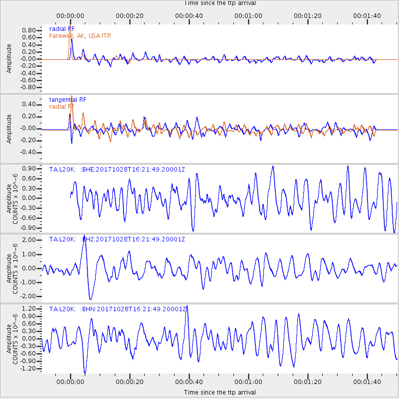
L20K Farewell, AK, USA - Earthquake Result Viewer
*The percent match for this event was below the threshold and hence no stack was calculated.
| Earthquake location: |
North Of Franz Josef Land |
| Earthquake latitude/longitude: |
86.9/52.8 |
| Earthquake time(UTC): |
2017/10/28 (301) 16:16:06 GMT |
| Earthquake Depth: |
10 km |
| Earthquake Magnitude: |
5.8 Mww |
| Earthquake Catalog/Contributor: |
NEIC PDE/us |
|
| Network: |
TA USArray Transportable Network (new EarthScope stations) |
| Station: |
L20K Farewell, AK, USA |
| Lat/Lon: |
62.48 N/153.88 W |
| Elevation: |
673 m |
|
| Distance: |
30.5 deg |
| Az: |
24.306 deg |
| Baz: |
357.228 deg |
| Ray Param: |
$rayparam |
*The percent match for this event was below the threshold and hence was not used in the summary stack. |
|
| Radial Match: |
69.76549 % |
| Radial Bump: |
336 |
| Transverse Match: |
56.305363 % |
| Transverse Bump: |
400 |
| SOD ConfigId: |
13570011 |
| Insert Time: |
2019-04-29 00:50:17.983 +0000 |
| GWidth: |
2.5 |
| Max Bumps: |
400 |
| Tol: |
0.001 |
|
Signal To Noise
| Channel | StoN | STA | LTA |
| TA:L20K: :BHZ:20171028T16:21:49.20001Z | 2.4080539 | 8.8679917E-7 | 3.6826384E-7 |
| TA:L20K: :BHN:20171028T16:21:49.20001Z | 1.4581978 | 4.70025E-7 | 3.223328E-7 |
| TA:L20K: :BHE:20171028T16:21:49.20001Z | 0.8849348 | 2.6860883E-7 | 3.0353516E-7 |
| Arrivals |
| Ps | |
| PpPs | |
| PsPs/PpSs | |


