You are here: Home > Network List > TM - Thai Seismic Monitoring Network Stations List
> Station MHIT MHIT Phase1 > Earthquake Result Viewer
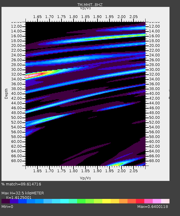
MHIT MHIT Phase1 - Earthquake Result Viewer
| Earthquake location: |
North Of Franz Josef Land |
| Earthquake latitude/longitude: |
86.9/52.8 |
| Earthquake time(UTC): |
2017/10/28 (301) 16:16:06 GMT |
| Earthquake Depth: |
10 km |
| Earthquake Magnitude: |
5.8 Mww |
| Earthquake Catalog/Contributor: |
NEIC PDE/us |
|
| Network: |
TM Thai Seismic Monitoring Network |
| Station: |
MHIT MHIT Phase1 |
| Lat/Lon: |
19.31 N/97.96 E |
| Elevation: |
270 m |
|
| Distance: |
68.6 deg |
| Az: |
134.06 deg |
| Baz: |
357.62 deg |
| Ray Param: |
0.056189515 |
| Estimated Moho Depth: |
32.5 km |
| Estimated Crust Vp/Vs: |
1.61 |
| Assumed Crust Vp: |
6.316 km/s |
| Estimated Crust Vs: |
3.917 km/s |
| Estimated Crust Poisson's Ratio: |
0.19 |
|
| Radial Match: |
89.614716 % |
| Radial Bump: |
266 |
| Transverse Match: |
66.403206 % |
| Transverse Bump: |
400 |
| SOD ConfigId: |
13570011 |
| Insert Time: |
2019-04-29 00:50:39.306 +0000 |
| GWidth: |
2.5 |
| Max Bumps: |
400 |
| Tol: |
0.001 |
|

Signal To Noise
| Channel | StoN | STA | LTA |
| TM:MHIT: :BHZ:20171028T16:26:38.559995Z | 2.477598 | 5.3187875E-7 | 2.1467517E-7 |
| TM:MHIT: :BHN:20171028T16:26:38.559995Z | 2.2979174 | 4.9677294E-7 | 2.1618399E-7 |
| TM:MHIT: :BHE:20171028T16:26:38.559995Z | 0.6509667 | 1.8617197E-7 | 2.8599308E-7 |
| Arrivals |
| Ps | 3.3 SECOND |
| PpPs | 13 SECOND |
| PsPs/PpSs | 16 SECOND |


