You are here: Home > Network List > AV - Alaska Volcano Observatory Stations List
> Station WACK Chichokna Glacier, Wrangell, Alaska > Earthquake Result Viewer
WACK Chichokna Glacier, Wrangell, Alaska - Earthquake Result Viewer
| Earthquake location: |
North Of Franz Josef Land |
| Earthquake latitude/longitude: |
86.9/55.1 |
| Earthquake time(UTC): |
2017/10/28 (301) 19:11:01 GMT |
| Earthquake Depth: |
10 km |
| Earthquake Magnitude: |
6.0 Mww |
| Earthquake Catalog/Contributor: |
NEIC PDE/us |
|
| Network: |
AV Alaska Volcano Observatory |
| Station: |
WACK Chichokna Glacier, Wrangell, Alaska |
| Lat/Lon: |
61.99 N/144.33 W |
| Elevation: |
2280 m |
|
| Distance: |
31.1 deg |
| Az: |
17.714 deg |
| Baz: |
357.985 deg |
| Ray Param: |
0.079147905 |
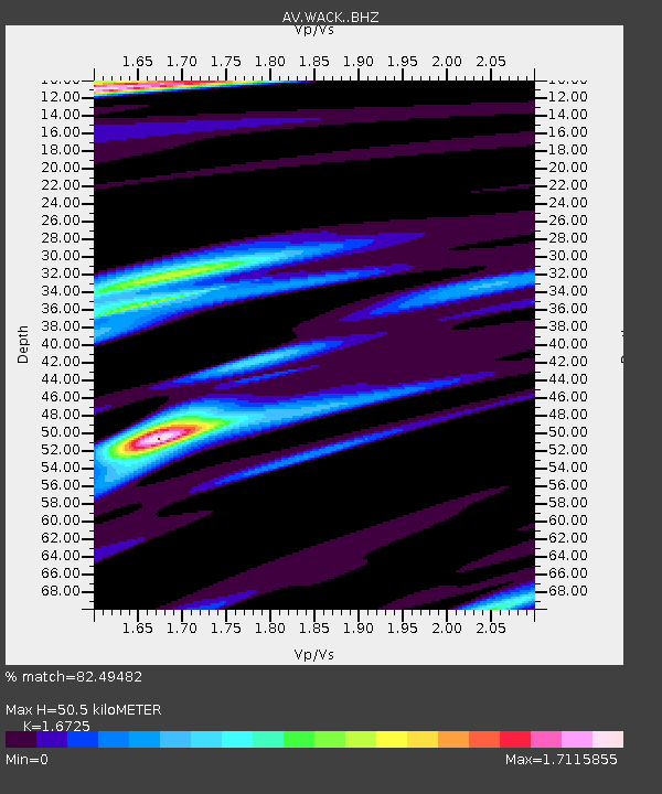
| Estimated Moho Depth: |
50.5 km |
| Estimated Crust Vp/Vs: |
1.67 |
| Assumed Crust Vp: |
6.566 km/s |
| Estimated Crust Vs: |
3.926 km/s |
| Estimated Crust Poisson's Ratio: |
0.22 |
|
| Radial Match: |
82.49482 % |
| Radial Bump: |
335 |
| Transverse Match: |
69.39374 % |
| Transverse Bump: |
400 |
| SOD ConfigId: |
13570011 |
| Insert Time: |
2019-04-29 00:53:33.474 +0000 |
| GWidth: |
2.5 |
| Max Bumps: |
400 |
| Tol: |
0.001 |
|

Signal To Noise
| Channel | StoN | STA | LTA |
| AV:WACK: :BHZ:20171028T19:16:50.580015Z | 3.134314 | 9.0619085E-7 | 2.8911936E-7 |
| AV:WACK: :BHN:20171028T19:16:50.580015Z | 2.5616927 | 5.7232E-7 | 2.2341479E-7 |
| AV:WACK: :BHE:20171028T19:16:50.580015Z | 1.0171593 | 2.7301093E-7 | 2.6840524E-7 |
| Arrivals |
| Ps | 5.7 SECOND |
| PpPs | 19 SECOND |
| PsPs/PpSs | 24 SECOND |


