You are here: Home > Network List > AV - Alaska Volcano Observatory Stations List
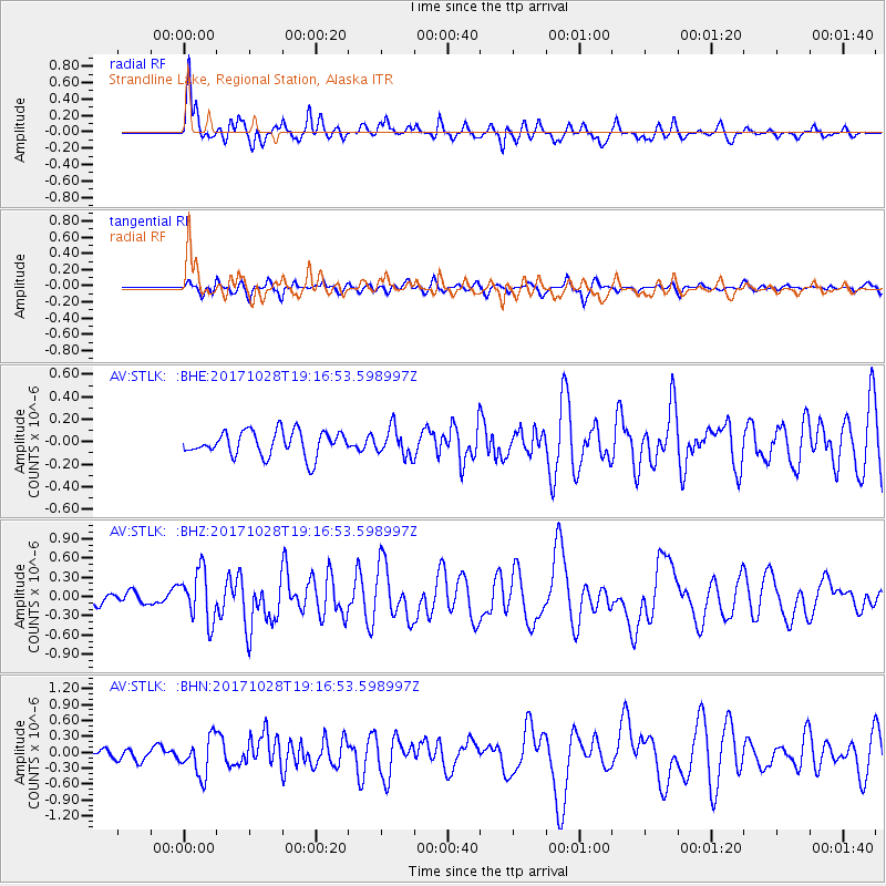
> Station STLK Strandline Lake, Regional Station, Alaska > Earthquake Result Viewer
STLK Strandline Lake, Regional Station, Alaska - Earthquake Result Viewer
| Earthquake location: |
North Of Franz Josef Land |
| Earthquake latitude/longitude: |
86.9/55.1 |
| Earthquake time(UTC): |
2017/10/28 (301) 19:11:01 GMT |
| Earthquake Depth: |
10 km |
| Earthquake Magnitude: |
6.0 Mww |
| Earthquake Catalog/Contributor: |
NEIC PDE/us |
|
| Network: |
AV Alaska Volcano Observatory |
| Station: |
STLK Strandline Lake, Regional Station, Alaska |
| Lat/Lon: |
61.50 N/151.83 W |
| Elevation: |
945 m |
|
| Distance: |
31.5 deg |
| Az: |
24.618 deg |
| Baz: |
357.284 deg |
| Ray Param: |
0.079058245 |
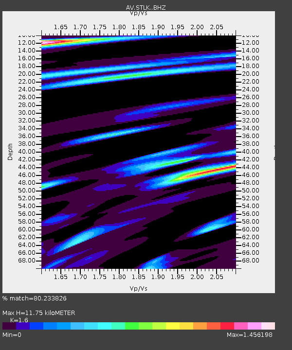
| Estimated Moho Depth: |
11.75 km |
| Estimated Crust Vp/Vs: |
1.60 |
| Assumed Crust Vp: |
6.302 km/s |
| Estimated Crust Vs: |
3.938 km/s |
| Estimated Crust Poisson's Ratio: |
0.18 |
|
| Radial Match: |
80.233826 % |
| Radial Bump: |
400 |
| Transverse Match: |
61.462845 % |
| Transverse Bump: |
400 |
| SOD ConfigId: |
13570011 |
| Insert Time: |
2019-04-29 00:53:33.658 +0000 |
| GWidth: |
2.5 |
| Max Bumps: |
400 |
| Tol: |
0.001 |
|
Signal To Noise
| Channel | StoN | STA | LTA |
| AV:STLK: :BHZ:20171028T19:16:53.598997Z | 3.9826903 | 3.9155398E-7 | 9.831394E-8 |
| AV:STLK: :BHN:20171028T19:16:53.598997Z | 3.6420708 | 3.483683E-7 | 9.565116E-8 |
| AV:STLK: :BHE:20171028T19:16:53.598997Z | 1.0374137 | 1.1605263E-7 | 1.11867266E-7 |
| Arrivals |
| Ps | 1.2 SECOND |
| PpPs | 4.5 SECOND |
| PsPs/PpSs | 5.7 SECOND |


