You are here: Home > Network List > CI - Caltech Regional Seismic Network Stations List
> Station MPM Manuel Prospect Mine, California, USA > Earthquake Result Viewer
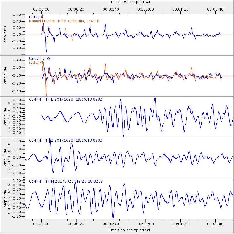
MPM Manuel Prospect Mine, California, USA - Earthquake Result Viewer
*The percent match for this event was below the threshold and hence no stack was calculated.
| Earthquake location: |
North Of Franz Josef Land |
| Earthquake latitude/longitude: |
86.9/55.1 |
| Earthquake time(UTC): |
2017/10/28 (301) 19:11:01 GMT |
| Earthquake Depth: |
10 km |
| Earthquake Magnitude: |
6.0 Mww |
| Earthquake Catalog/Contributor: |
NEIC PDE/us |
|
| Network: |
CI Caltech Regional Seismic Network |
| Station: |
MPM Manuel Prospect Mine, California, USA |
| Lat/Lon: |
36.06 N/117.49 W |
| Elevation: |
185 m |
|
| Distance: |
57.2 deg |
| Az: |
352.893 deg |
| Baz: |
0.477 deg |
| Ray Param: |
$rayparam |
*The percent match for this event was below the threshold and hence was not used in the summary stack. |
|
| Radial Match: |
79.33189 % |
| Radial Bump: |
321 |
| Transverse Match: |
75.01169 % |
| Transverse Bump: |
353 |
| SOD ConfigId: |
13570011 |
| Insert Time: |
2019-04-29 00:54:47.311 +0000 |
| GWidth: |
2.5 |
| Max Bumps: |
400 |
| Tol: |
0.001 |
|
Signal To Noise
| Channel | StoN | STA | LTA |
| CI:MPM: :HHZ:20171028T19:20:18.828Z | 3.871698 | 7.191744E-7 | 1.8575169E-7 |
| CI:MPM: :HHN:20171028T19:20:18.828Z | 1.7308178 | 4.137128E-7 | 2.3902734E-7 |
| CI:MPM: :HHE:20171028T19:20:18.828Z | 1.0743568 | 1.5079408E-7 | 1.4035754E-7 |
| Arrivals |
| Ps | |
| PpPs | |
| PsPs/PpSs | |


