You are here: Home > Network List > CI - Caltech Regional Seismic Network Stations List
> Station SLA SLA, Trona, CA, USA > Earthquake Result Viewer
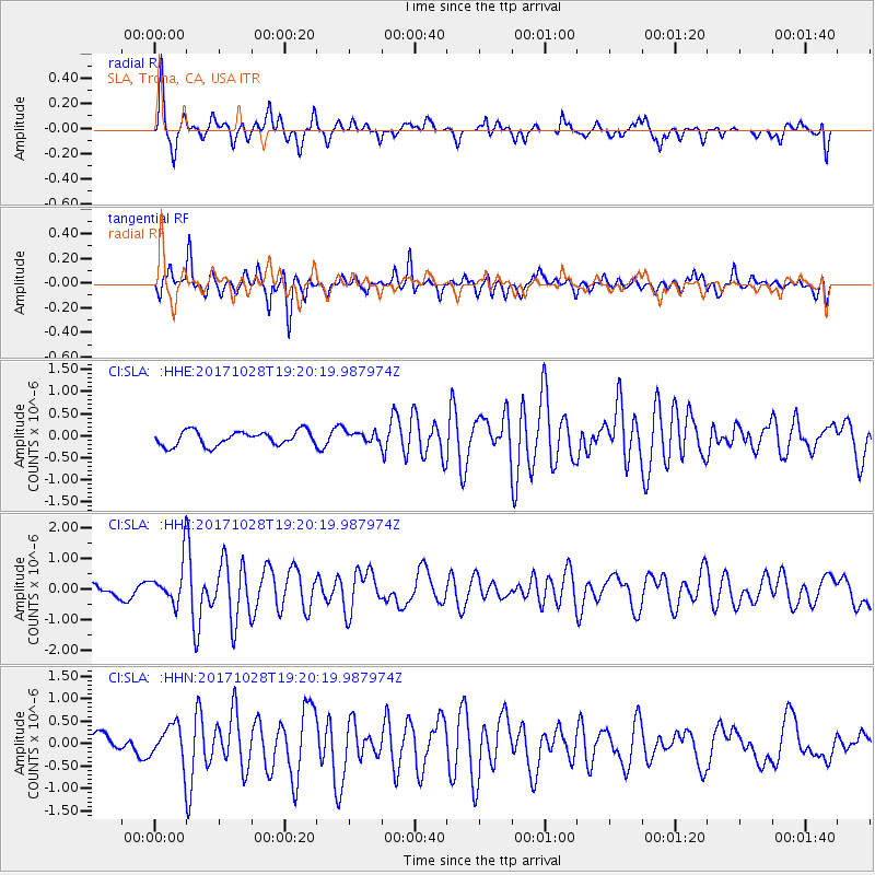
SLA SLA, Trona, CA, USA - Earthquake Result Viewer
*The percent match for this event was below the threshold and hence no stack was calculated.
| Earthquake location: |
North Of Franz Josef Land |
| Earthquake latitude/longitude: |
86.9/55.1 |
| Earthquake time(UTC): |
2017/10/28 (301) 19:11:01 GMT |
| Earthquake Depth: |
10 km |
| Earthquake Magnitude: |
6.0 Mww |
| Earthquake Catalog/Contributor: |
NEIC PDE/us |
|
| Network: |
CI Caltech Regional Seismic Network |
| Station: |
SLA SLA, Trona, CA, USA |
| Lat/Lon: |
35.89 N/117.28 W |
| Elevation: |
1174 m |
|
| Distance: |
57.4 deg |
| Az: |
352.693 deg |
| Baz: |
0.49 deg |
| Ray Param: |
$rayparam |
*The percent match for this event was below the threshold and hence was not used in the summary stack. |
|
| Radial Match: |
79.17709 % |
| Radial Bump: |
389 |
| Transverse Match: |
76.420296 % |
| Transverse Bump: |
400 |
| SOD ConfigId: |
13570011 |
| Insert Time: |
2019-04-29 00:54:58.176 +0000 |
| GWidth: |
2.5 |
| Max Bumps: |
400 |
| Tol: |
0.001 |
|
Signal To Noise
| Channel | StoN | STA | LTA |
| CI:SLA: :HHZ:20171028T19:20:19.987974Z | 5.7116 | 7.393529E-7 | 1.294476E-7 |
| CI:SLA: :HHN:20171028T19:20:19.987974Z | 2.0244439 | 4.4690555E-7 | 2.2075471E-7 |
| CI:SLA: :HHE:20171028T19:20:19.987974Z | 0.9968499 | 1.6463915E-7 | 1.651594E-7 |
| Arrivals |
| Ps | |
| PpPs | |
| PsPs/PpSs | |


