You are here: Home > Network List > CI - Caltech Regional Seismic Network Stations List
> Station TUQ Turquiose Mountain, Baker, CA, USA > Earthquake Result Viewer
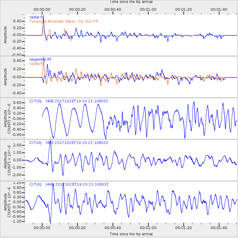
TUQ Turquiose Mountain, Baker, CA, USA - Earthquake Result Viewer
*The percent match for this event was below the threshold and hence no stack was calculated.
| Earthquake location: |
North Of Franz Josef Land |
| Earthquake latitude/longitude: |
86.9/55.1 |
| Earthquake time(UTC): |
2017/10/28 (301) 19:11:01 GMT |
| Earthquake Depth: |
10 km |
| Earthquake Magnitude: |
6.0 Mww |
| Earthquake Catalog/Contributor: |
NEIC PDE/us |
|
| Network: |
CI Caltech Regional Seismic Network |
| Station: |
TUQ Turquiose Mountain, Baker, CA, USA |
| Lat/Lon: |
35.44 N/115.92 W |
| Elevation: |
1350 m |
|
| Distance: |
57.8 deg |
| Az: |
351.377 deg |
| Baz: |
0.574 deg |
| Ray Param: |
$rayparam |
*The percent match for this event was below the threshold and hence was not used in the summary stack. |
|
| Radial Match: |
75.48491 % |
| Radial Bump: |
321 |
| Transverse Match: |
54.129894 % |
| Transverse Bump: |
400 |
| SOD ConfigId: |
13570011 |
| Insert Time: |
2019-04-29 00:55:03.498 +0000 |
| GWidth: |
2.5 |
| Max Bumps: |
400 |
| Tol: |
0.001 |
|
Signal To Noise
| Channel | StoN | STA | LTA |
| CI:TUQ: :HHZ:20171028T19:20:23.10803Z | 3.4488873 | 1.0135232E-6 | 2.938696E-7 |
| CI:TUQ: :HHN:20171028T19:20:23.10803Z | 1.7253608 | 4.6809564E-7 | 2.7130307E-7 |
| CI:TUQ: :HHE:20171028T19:20:23.10803Z | 0.9976116 | 3.6647353E-7 | 3.673509E-7 |
| Arrivals |
| Ps | |
| PpPs | |
| PsPs/PpSs | |


