You are here: Home > Network List > TA - USArray Transportable Network (new EarthScope stations) Stations List
> Station S15A Panguitch, AZ, USA > Earthquake Result Viewer
S15A Panguitch, AZ, USA - Earthquake Result Viewer
| Earthquake location: |
Solomon Islands |
| Earthquake latitude/longitude: |
-10.5/161.3 |
| Earthquake time(UTC): |
2008/06/03 (155) 16:20:50 GMT |
| Earthquake Depth: |
84 km |
| Earthquake Magnitude: |
6.2 MB, 6.2 MW, 6.2 MW |
| Earthquake Catalog/Contributor: |
WHDF/NEIC |
|
| Network: |
TA USArray Transportable Network (new EarthScope stations) |
| Station: |
S15A Panguitch, AZ, USA |
| Lat/Lon: |
37.68 N/112.36 W |
| Elevation: |
2102 m |
|
| Distance: |
93.5 deg |
| Az: |
52.498 deg |
| Baz: |
259.509 deg |
| Ray Param: |
0.0412081 |
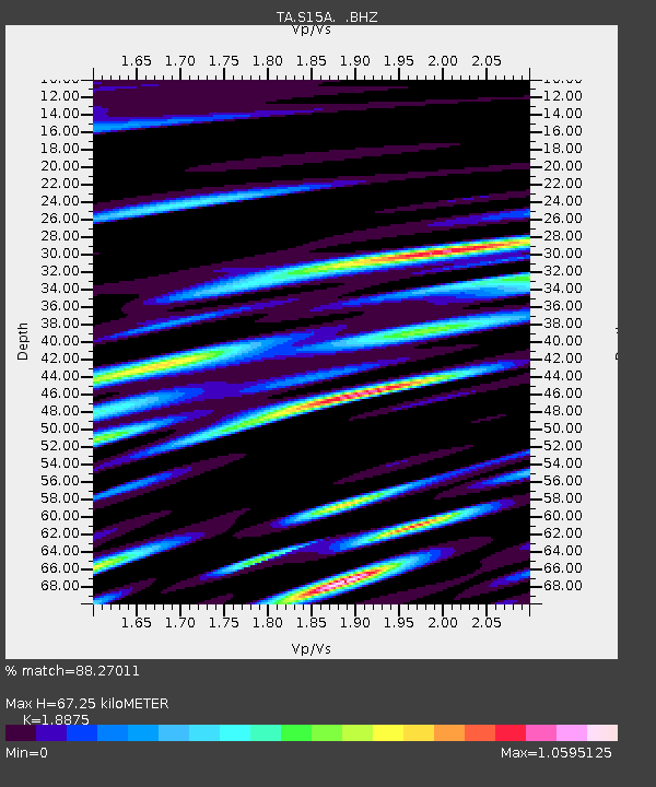
| Estimated Moho Depth: |
67.25 km |
| Estimated Crust Vp/Vs: |
1.89 |
| Assumed Crust Vp: |
6.194 km/s |
| Estimated Crust Vs: |
3.282 km/s |
| Estimated Crust Poisson's Ratio: |
0.30 |
|
| Radial Match: |
88.27011 % |
| Radial Bump: |
400 |
| Transverse Match: |
63.390026 % |
| Transverse Bump: |
400 |
| SOD ConfigId: |
2504 |
| Insert Time: |
2010-03-06 05:31:24.101 +0000 |
| GWidth: |
2.5 |
| Max Bumps: |
400 |
| Tol: |
0.001 |
|

Signal To Noise
| Channel | StoN | STA | LTA |
| TA:S15A: :BHZ:20080603T16:33:25.374019Z | 11.305955 | 9.984484E-7 | 8.831173E-8 |
| TA:S15A: :BHN:20080603T16:33:25.374019Z | 0.5947432 | 2.659517E-7 | 4.4717066E-7 |
| TA:S15A: :BHE:20080603T16:33:25.374019Z | 0.9286617 | 8.891757E-8 | 9.574807E-8 |
| Arrivals |
| Ps | 9.8 SECOND |
| PpPs | 31 SECOND |
| PsPs/PpSs | 41 SECOND |


