You are here: Home > Network List > CI - Caltech Regional Seismic Network Stations List
> Station SMM Simmler, CA, USA > Earthquake Result Viewer
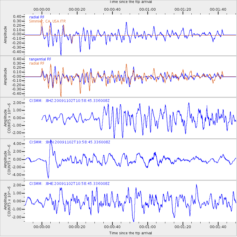
SMM Simmler, CA, USA - Earthquake Result Viewer
*The percent match for this event was below the threshold and hence no stack was calculated.
| Earthquake location: |
South Of Tonga Islands |
| Earthquake latitude/longitude: |
-24.1/-175.2 |
| Earthquake time(UTC): |
2009/11/02 (306) 10:47:13 GMT |
| Earthquake Depth: |
9.0 km |
| Earthquake Magnitude: |
6.1 MB, 6.1 MS, 6.2 MW, 6.1 MW |
| Earthquake Catalog/Contributor: |
WHDF/NEIC |
|
| Network: |
CI Caltech Regional Seismic Network |
| Station: |
SMM Simmler, CA, USA |
| Lat/Lon: |
35.31 N/120.00 W |
| Elevation: |
599 m |
|
| Distance: |
78.9 deg |
| Az: |
43.173 deg |
| Baz: |
229.856 deg |
| Ray Param: |
$rayparam |
*The percent match for this event was below the threshold and hence was not used in the summary stack. |
|
| Radial Match: |
78.50991 % |
| Radial Bump: |
400 |
| Transverse Match: |
70.0573 % |
| Transverse Bump: |
400 |
| SOD ConfigId: |
2622 |
| Insert Time: |
2010-02-26 01:33:09.768 +0000 |
| GWidth: |
2.5 |
| Max Bumps: |
400 |
| Tol: |
0.001 |
|
Signal To Noise
| Channel | StoN | STA | LTA |
| CI:SMM: :BHN:20091102T10:58:45.336008Z | 7.2237287 | 2.0710722E-6 | 2.8670405E-7 |
| CI:SMM: :BHE:20091102T10:58:45.336008Z | 1.7945713 | 4.5022168E-7 | 2.508798E-7 |
| CI:SMM: :BHZ:20091102T10:58:45.336008Z | 1.8577192 | 6.661968E-7 | 3.5861007E-7 |
| Arrivals |
| Ps | |
| PpPs | |
| PsPs/PpSs | |


